IMAGES TAKEN NEAR TO
Gelli Farm Lane, NEWPORT, NP11 3AZ
Introduction
This page details the photographs taken nearby to Gelli Farm Lane, NP11 3AZ by members of the Geograph project.
The Geograph project started in 2005 with the aim of publishing, organising and preserving representative images for every square kilometre of Great Britain, Ireland and the Isle of Man.

There are currently over 7.5m images from over14,400 individuals and you can help contribute to the project by visiting https://www.geograph.org.uk
Image Map
Images are licensed for reuse under creativecommons.org/licenses/by-sa/2.0
Notes
- Clicking on the map will re-center to the selected point.
- The higher the marker number, the further away the image location is from the centre of the postcode.
Image Listing (30 Images Found)
Images are licensed for reuse under creativecommons.org/licenses/by-sa/2.0
Image
Details
Distance
1
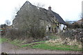
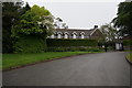
Derelict historic farmhouse, Gelli
Disused seventeenth century small farmhouse with farm range (nearest to track), Grade II listed, associated with historic regional barn Image
Image: © M J Roscoe
Taken: 18 Mar 2017
0.01 miles
2
Farm at Gelli
The long building in the centre with part of the roof missing is a Grade II listed disused seventeenth century farmhouse and range Image
Image: © M J Roscoe
Taken: 7 Apr 2018
0.02 miles
3
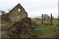
Ruined historic barn, Gelli
Gable end of roofless building near footpath stile Image; The sign on the wall says, 'Dangerous structure Keep clear'. The barn is Grade II listed and associated with an older farmhouse Image
Image: © M J Roscoe
Taken: 18 Mar 2017
0.02 miles
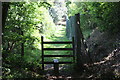
4
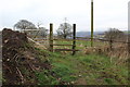
Damaged stile to footpath, Gelli
Wooden stile, with step missing, at start of public footpath through fields.
Image: © M J Roscoe
Taken: 18 Mar 2017
0.03 miles
5
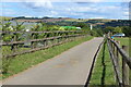
Gelli Farm Lane
Private road from Parkway leading to recently opened Fferm Gelli Campsite at Gelli Farm.
Image: © M J Roscoe
Taken: 5 Aug 2022
0.05 miles
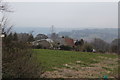
6
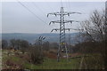
Three electricity pylons near Gelli
Transmission lines junction on the edge of Pen-y-fan Industrial Estate. The far side of the Ebbw Valley is in the background.
Image: © M J Roscoe
Taken: 7 Apr 2018
0.06 miles
8
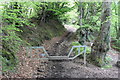
Bridleway to Pen-y-fan Pond
Start of muddy bridleway up towards Pen-y-fan Pond from lane on the west of Trinant.
Image: © M J Roscoe
Taken: 15 May 2016
0.10 miles
9
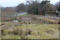
Pond off Parkway
Pond on marshy ground at junction of track with Parkway almost opposite Pen-y-fan Country Park (top left). Most of the pond dries up in summer.
Image: © M J Roscoe
Taken: 7 Apr 2018
0.12 miles
10
Footpath behind Pen-y-fan Industrial Estate
Stile from byway to public footpath here running alongside a security fence.
Image: © M J Roscoe
Taken: 25 May 2020
0.12 miles