IMAGES TAKEN NEAR TO
Kendon Road, NEWPORT, NP11 3AP
Introduction
This page details the photographs taken nearby to Kendon Road, NP11 3AP by members of the Geograph project.
The Geograph project started in 2005 with the aim of publishing, organising and preserving representative images for every square kilometre of Great Britain, Ireland and the Isle of Man.

There are currently over 7.5m images from over14,400 individuals and you can help contribute to the project by visiting https://www.geograph.org.uk
Image Map
Images are licensed for reuse under creativecommons.org/licenses/by-sa/2.0
Notes
- Clicking on the map will re-center to the selected point.
- The higher the marker number, the further away the image location is from the centre of the postcode.
Image Listing (133 Images Found)
Images are licensed for reuse under creativecommons.org/licenses/by-sa/2.0
Image
Details
Distance
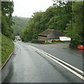
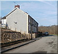
2
Derelict offices, Kendon Road, Crumlin
Looking to have been long since abandoned, a row of single-storey derelict offices extends for about 80 metres along Kendon Road (B4251).
Image: © Jaggery
Taken: 17 Feb 2011
0.03 miles
3
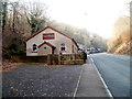
Rock Fellowship church, Crumlin
Located on Kendon Road (B4251). The church building dates from 1935, when it was The Full Gospel Mission, a name it kept until changed to its current name in 2000.
Image: © Jaggery
Taken: 17 Feb 2011
0.04 miles
5
Kennard Terrace, Crumlin
The houses are at the southern end of Kennard Terrace, viewed from the edge of the Bridgend Inn.http://www.geograph.org.uk/photo/2299107
The terrace is named after the builder of the Crumlin Viaduct, depicted in the Inn's sign. http://www.geograph.org.uk/photo/2299113
Image: © Jaggery
Taken: 17 Feb 2011
0.09 miles
6
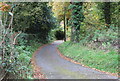
Load of Hay Lane, above Crumlin
The start of the narrower section of the Lane down to Crumlin
Image: © M J Roscoe
Taken: 23 Oct 2015
0.09 miles
7
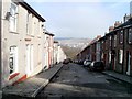
Looking down William Street, Treowen
William Street is about 110 metres long. The 49 houses are numbered in sequence. On the right side, from 1 to 26 uphill and 27 to 49 downhill on the opposite side.
Image: © Jaggery
Taken: 17 Feb 2011
0.09 miles
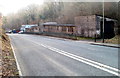
8
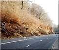
Muddy track heads away from Kendon Road near Crumlin
Viewed from the south side of Kendon Road (B4251) on the long descent to Crumlin through a wood named Cwm Kendon.
Image: © Jaggery
Taken: 17 Feb 2011
0.10 miles
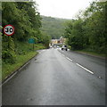
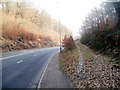
9
Keep in low gear : 7% descent ahead on the approach to Crumlin
About 500 metres from the junction with the A467(ahead), a sign on the side of Kendon Road (B4251) shows there is a 7% (1 in 14) descent ahead.
Image: © Jaggery
Taken: 17 Feb 2011
0.10 miles
10
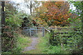
Ebbw Valley Walk, Load of Hay Lane
Path going to Trinant from Lane. The enclosure on the right appears to be for livestock in transit, and possibly small vehicles.
Image: © M J Roscoe
Taken: 23 Oct 2015
0.10 miles