IMAGES TAKEN NEAR TO
Mountain Road, NEWPORT, NP10 9US
Introduction
This page details the photographs taken nearby to Mountain Road, NP10 9US by members of the Geograph project.
The Geograph project started in 2005 with the aim of publishing, organising and preserving representative images for every square kilometre of Great Britain, Ireland and the Isle of Man.

There are currently over 7.5m images from over14,400 individuals and you can help contribute to the project by visiting https://www.geograph.org.uk
Image Map
Images are licensed for reuse under creativecommons.org/licenses/by-sa/2.0
Notes
- Clicking on the map will re-center to the selected point.
- The higher the marker number, the further away the image location is from the centre of the postcode.
Image Listing (60 Images Found)
Images are licensed for reuse under creativecommons.org/licenses/by-sa/2.0
Image
Details
Distance
1
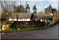
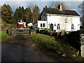
Ty-yn-yr-ardd, Mountain Road, Rogerstone, Newport
House in a converted former barn at the southeast end of Mountain Road, viewed from the corner of Groes Road.
Image: © Jaggery
Taken: 23 Jan 2014
0.00 miles
2
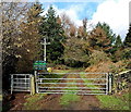
Southern entrance to Mescoed Mawr
From Mountain Road at the edge of Rogerstone, Newport. Walkers can use the kissing gate
on the left to enter the Forestry Commission Wales woodland Mescoed Mawr.
Image: © Jaggery
Taken: 23 Jan 2014
0.01 miles
3
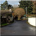
Southeast end of Mountain Road, Rogerstone, Newport
From the Groes Road junction. An entrance to woodland (Mescoed Mawr) is ahead on the right.
Image: © Jaggery
Taken: 23 Jan 2014
0.01 miles
4
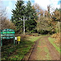
Nameboard and two warning notices at the southern entrance to Mescoed Mawr
This is the Forestry Commission Wales woodland Mescoed Mawr. http://www.geograph.org.uk/photo/4025667 to the two warnings.
Image: © Jaggery
Taken: 23 Jan 2014
0.02 miles
5
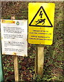
Two warning notices at the southern entrance to Mescoed Mawr
Located here. http://www.geograph.org.uk/photo/4025666 The yellow notice warns of overhead electric lines. The other notice states
that it is a criminal offence to use any form of firearm (include air guns) on Forestry Commission land.
Image: © Jaggery
Taken: 23 Jan 2014
0.02 miles
6
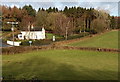
Maescoed Cottage at the edge of Rogerstone, Newport
Set back from the southeast end of Mountain Road, near the Groes Road and Cwm Lane junctions.
Image: © Jaggery
Taken: 23 Jan 2014
0.02 miles
7
Fields on the east side of Groes Road, Rogerstone, Newport
Viewed from Cwm Lane. Maescoed Cottage www.geograph.org.uk/photo/4793831 is on the left.
Image: © Jaggery
Taken: 23 Jan 2014
0.02 miles
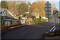
8
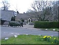
Croesllanfro farm
Situated at the crossing of four minor roads.
Image: © Roger Cornfoot
Taken: 1 Mar 2007
0.02 miles
9
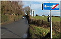
No left turn into Mountain Road for lorries, Rogerstone, Newport
The sign is alongside Groes Road.
Image: © Jaggery
Taken: 23 Jan 2014
0.02 miles
10
End of the 20mph zone along Groes Road, Rogerstone, Newport
On the approach to the Cwm Lane junction, the speed limit increases to the National Speed Limit.
Image: © Jaggery
Taken: 23 Jan 2014
0.03 miles