IMAGES TAKEN NEAR TO
De Haia Road, NEWPORT, NP10 9NT
Introduction
This page details the photographs taken nearby to De Haia Road, NP10 9NT by members of the Geograph project.
The Geograph project started in 2005 with the aim of publishing, organising and preserving representative images for every square kilometre of Great Britain, Ireland and the Isle of Man.

There are currently over 7.5m images from over14,400 individuals and you can help contribute to the project by visiting https://www.geograph.org.uk
Image Map
Images are licensed for reuse under creativecommons.org/licenses/by-sa/2.0
Notes
- Clicking on the map will re-center to the selected point.
- The higher the marker number, the further away the image location is from the centre of the postcode.
Image Listing (61 Images Found)
Images are licensed for reuse under creativecommons.org/licenses/by-sa/2.0
Image
Details
Distance
1
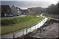
Jubilee Park Walk, Jubilee Park, Rogerstone
Sinuous path/cycleway encircling a new housing estate on a former industrial site next to the flood defence wall on the extreme right; viewed from end of new footbridge Image over the path and flood defence wall.
Image: © M J Roscoe
Taken: 20 Oct 2017
0.09 miles
2
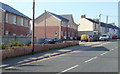
Newer and older houses, Tregwilym Road, Rogerstone
View from a Tregwilym Road bus stop.
Image: © Jaggery
Taken: 4 Mar 2011
0.10 miles
3
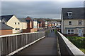
Footbridge into Jubilee Park, Rogerstone
Footbridge, from Ebbw footbridge Image, over flood defence and Jubilee Park Way to Jubilee Way in new housing estate on reclaimed industrial land.
Image: © M J Roscoe
Taken: 20 Oct 2017
0.10 miles
4
Two semis, Tregwilym Road, Rogerstone
The two semi-detached houses face Dudley's premises. http://www.geograph.org.uk/photo/1663474
Image: © Jaggery
Taken: 4 Mar 2011
0.12 miles
5
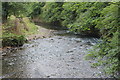
River Ebbw downstream from footbridge
River flowing alongside former industrial site, viewed from opposite side of same footbridge as upstream view Image
Image: © M J Roscoe
Taken: 10 Jul 2017
0.13 miles
6
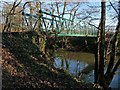
Footbridge over the River Ebbw
On the route of the Sirhowy Valley Walk.
Image: © Robin Drayton
Taken: 11 Jan 2013
0.14 miles
7
Footbridge over River Ebbw, Rogerstone
Public footpath, part of the Sirhowy Valley Walk, with part of the new Jubilee Park housing estate in the background.
Image: © M J Roscoe
Taken: 20 Oct 2017
0.14 miles
8
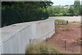
Flood defences alongside River Ebbw
Concrete wall to protect new housing estate on former industrial site, right; the wall in the background borders a recreation ground.
Image: © M J Roscoe
Taken: 10 Jul 2017
0.14 miles
9
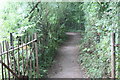
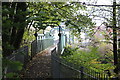
Footpath to footbridge over River Ebbw
Public footpath, part of the Sirhowy Valley Walk, through riverside woodland down to bridge.
Image: © M J Roscoe
Taken: 10 Jul 2017
0.14 miles
10
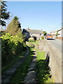
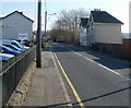
Ty-du Lane, Rogerstone
Viewed from Tregwilym Road.
Image: © Jaggery
Taken: 12 Oct 2009
0.14 miles