IMAGES TAKEN NEAR TO
Obama Grove, NEWPORT, NP10 9NP
Introduction
This page details the photographs taken nearby to Obama Grove, NP10 9NP by members of the Geograph project.
The Geograph project started in 2005 with the aim of publishing, organising and preserving representative images for every square kilometre of Great Britain, Ireland and the Isle of Man.

There are currently over 7.5m images from over14,400 individuals and you can help contribute to the project by visiting https://www.geograph.org.uk
Image Map
Images are licensed for reuse under creativecommons.org/licenses/by-sa/2.0
Notes
- Clicking on the map will re-center to the selected point.
- The higher the marker number, the further away the image location is from the centre of the postcode.
Image Listing (53 Images Found)
Images are licensed for reuse under creativecommons.org/licenses/by-sa/2.0
Image
Details
Distance
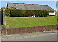
1
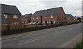
Obama Grove houses, Rogerstone, Newport
Viewed from Tregwilym Road in April 2017. Accessed from Jubilee Way, Obama Grove is one of several new streets built on the former Alcan site. Construction work elsewhere on the site is ongoing.
Image: © Jaggery
Taken: 20 Apr 2017
0.02 miles
2
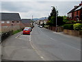
Decades apart, Tregwilym Road, Rogerstone, Newport
The houses on the left, on the former Alcan site, were built in the
second decade of the 21st century, many decades after the houses on the right.
Image: © Jaggery
Taken: 20 Apr 2017
0.03 miles
3
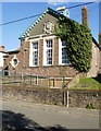
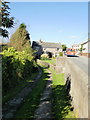
Rogerstone Library
Now part of Newport City Council's library service, and officially titled Rogerstone Library and Information Centre, the building was opened in 1905 as a Carnegie Free Library. Carnegie libraries were built with money donated by Scottish-American businessman and philanthropist Andrew Carnegie. More than 2,500 Carnegie libraries were built worldwide. The other one in the city of Newport is on Corporation Road. http://www.geograph.org.uk/photo/1621495
Rogerstone Library was Grade II listed in 2003.
Image: © Jaggery
Taken: 12 Oct 2009
0.04 miles
4
Tregwilym Road houses, Rogerstone
Houses on the east side of Tregwilym Road.
Image: © Jaggery
Taken: 12 Oct 2009
0.04 miles
5
Ty-du Lane, Rogerstone
Viewed from Tregwilym Road.
Image: © Jaggery
Taken: 12 Oct 2009
0.04 miles
6
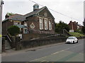
Grade II Listed Rogerstone Library, Newport
Viewed across Tregwilym Road. Now part of Newport City Council's library service, and officially titled Rogerstone Library and Information Centre, the building was opened in 1905 as a Carnegie Free Library. Carnegie libraries were built with money donated by Scottish-American businessman and philanthropist Andrew Carnegie. More than 2,500 Carnegie libraries were built worldwide. The other one in the city of Newport is in Corporation Road. http://www.geograph.org.uk/photo/1621495
Rogerstone Library was Grade II listed in 2003.
Image: © Jaggery
Taken: 20 Apr 2017
0.05 miles
7
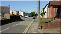
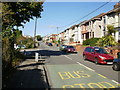
Tregwilym Road Rogerstone boundary marker
Looking northwestwards along Tregwilym Road.
At the lower right of the photo, next to the telephone post, is a small metal post http://www.geograph.org.uk/photo/1663021 that was formerly a boundary marker for the Great Western Railway. It is dated 1916.
Image: © Jaggery
Taken: 12 Oct 2009
0.05 miles
8
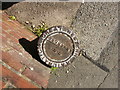
Great Western Railway boundary marker, Rogerstone
Photo taken directly above a small boundary marker located on the east side of Tregwilym Road. http://www.geograph.org.uk/photo/1663042 The text in a circle around the edge reads GREAT WESTERN RAILWAY CO. The text in the middle is BOUNDARY 1916.
Image: © Jaggery
Taken: 12 Oct 2009
0.05 miles
9
Royal British Legion, Rogerstone branch
Set back from, and raised a little above, Tregwilym Road.
Image: © Jaggery
Taken: 12 Oct 2009
0.05 miles
10
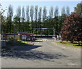
Entrance to Novalis, Rogerstone
The Tregwilym Road entrance to the former Novalis site.
440 people lost their jobs when aluminium firm Novelis ceased production at its Rogerstone plant in April 2009. The company said orders were down 60 per cent and the site, which supplied aluminium sheets and coils to the construction and engineering industries, was losing £1.5 million a month.
Image: © Jaggery
Taken: 12 Oct 2009
0.05 miles