IMAGES TAKEN NEAR TO
Hurricane Way, NEWPORT, NP10 9NJ
Introduction
This page details the photographs taken nearby to Hurricane Way, NP10 9NJ by members of the Geograph project.
The Geograph project started in 2005 with the aim of publishing, organising and preserving representative images for every square kilometre of Great Britain, Ireland and the Isle of Man.

There are currently over 7.5m images from over14,400 individuals and you can help contribute to the project by visiting https://www.geograph.org.uk
Image Map
Images are licensed for reuse under creativecommons.org/licenses/by-sa/2.0
Notes
- Clicking on the map will re-center to the selected point.
- The higher the marker number, the further away the image location is from the centre of the postcode.
Image Listing (82 Images Found)
Images are licensed for reuse under creativecommons.org/licenses/by-sa/2.0
Image
Details
Distance
1
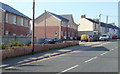
Newer and older houses, Tregwilym Road, Rogerstone
View from a Tregwilym Road bus stop.
Image: © Jaggery
Taken: 4 Mar 2011
0.04 miles
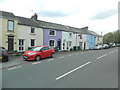
2
Two semis, Tregwilym Road, Rogerstone
The two semi-detached houses face Dudley's premises. http://www.geograph.org.uk/photo/1663474
Image: © Jaggery
Taken: 4 Mar 2011
0.05 miles
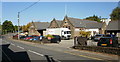
4
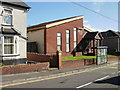
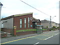
Rogerstone Pentecostal Church
Located on Tregwilym Road.
Image: © Jaggery
Taken: 12 Oct 2009
0.09 miles
5
Dudley's Tydu Works, Tregwilym Road, Rogerstone
256-260 Tregwilym Road. S Dudley & Sons Ltd are contractors specialising in
construction, shopfitting and bespoke architectural aluminium facade products.
The buildings were formerly the Rogerstone and Henllis School Board School.
Henllis is now spelt Henllys. The Rogerstone and Henllis School Board was
established in 1874 under the terms of the Elementary Education Act 1870. School Boards were elected bodies, empowered to levy rates and to set up and maintain schools in areas where voluntary provision was inadequate.
The school was built in 1877 and enlarged in 1889. Its capacity was 600 children. A report in 1953 stated that the school buildings and site were ‘very defective’ and that ‘modern accommodation was necessary.’, but it was not until 1976 that a new school elsewhere in Rogerstone allowed the old school to close.
Image: © Jaggery
Taken: 12 Oct 2009
0.10 miles
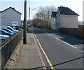
6
School Terrace, Rogerstone
School Terrace is between the west side of Tregwilym Road and Rogerstone Welfare Ground.
Image: © Jaggery
Taken: 12 Oct 2009
0.10 miles
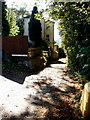
7
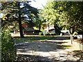
Entrance to Rogerstone Welfare Ground
The Welfare Ground, a recreation area, is reached from Tregwilym Road.
Image: © Jaggery
Taken: 12 Oct 2009
0.10 miles
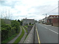
10
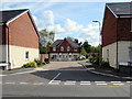
Scholars Close, Rogerstone
Recently-built houses viewed across Tregwilym Road in May 2018.
Image: © Jaggery
Taken: 1 May 2018
0.11 miles