IMAGES TAKEN NEAR TO
Ffordd Camlas, NEWPORT, NP10 9LW
Introduction
This page details the photographs taken nearby to Ffordd Camlas, NP10 9LW by members of the Geograph project.
The Geograph project started in 2005 with the aim of publishing, organising and preserving representative images for every square kilometre of Great Britain, Ireland and the Isle of Man.

There are currently over 7.5m images from over14,400 individuals and you can help contribute to the project by visiting https://www.geograph.org.uk
Image Map
Images are licensed for reuse under creativecommons.org/licenses/by-sa/2.0
Notes
- Clicking on the map will re-center to the selected point.
- The higher the marker number, the further away the image location is from the centre of the postcode.
Image Listing (162 Images Found)
Images are licensed for reuse under creativecommons.org/licenses/by-sa/2.0
Image
Details
Distance
1
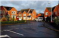
Ffordd Camlas, Rogerstone, Newport
Modern houses viewed from the corner of Cwrt Camlas near Serennu Children's Centre. http://www.geograph.org.uk/photo/3824292
Image: © Jaggery
Taken: 23 Jan 2014
0.03 miles
2
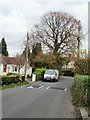
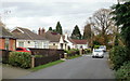
Cwm Lane, High Cross, Newport
The tree marks the point where Cwm Lane bends sharply to the left as it heads towards Fourteen Locks.
Image: © Jaggery
Taken: 19 Nov 2009
0.04 miles
3
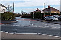
20mph speed limit along Cwm Lane, Rogerstone, Newport
Viewed across the B4591. The cars are in Cefn Smithy Garage. http://www.geograph.org.uk/photo/3824399
Image: © Jaggery
Taken: 23 Jan 2014
0.08 miles
4

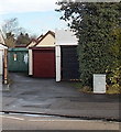
Cefn Smithy Garage, Rogerstone, Newport
Occupying a site on the corner of High Cross Road and Cwm Lane.
Image: © Jaggery
Taken: 23 Jan 2014
0.08 miles
5
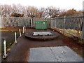
Sewage pumping station near Serennu, Newport
Viewed through the compound fence on the left in this http://www.geograph.org.uk/photo/3824305 view.
Image: © Jaggery
Taken: 23 Jan 2014
0.08 miles
6
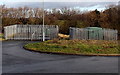
Two compounds near Serennu, Newport
Sewage pumping station http://www.geograph.org.uk/photo/3824367 on the left, Western Power Distribution electricity substation on the right. Located on the NW side of Serennu Children's Centre. http://www.geograph.org.uk/photo/3824292
Image: © Jaggery
Taken: 23 Jan 2014
0.08 miles
7
Cwm Lane, High Cross, Newport
The view along Cwm Lane heading away from Highcross Road towards Fourteen Locks.
Image: © Jaggery
Taken: 19 Nov 2009
0.09 miles
8
Well-hidden electricity substation near Cwm Lane, Rogerstone, Newport
It was only the familiar dark green colour which caught my eye as I walked along the pavement on the opposite side of the road. The substation is set back 20 metres from the north side of the B4591, behind garages, near the Cwm Lane junction.
Image: © Jaggery
Taken: 23 Jan 2014
0.09 miles
9
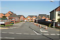
Ffordd Camlas, Rogerstone
Modern housing (built about 2007) viewed from Highcross Road.
Image: © Jaggery
Taken: 12 Oct 2009
0.10 miles
10
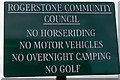
Rogerstone Community Council notice, Newport
Located at the High Cross Road end of this http://www.geograph.org.uk/photo/3826418 open space.
Image: © Jaggery
Taken: 23 Jan 2014
0.11 miles