IMAGES TAKEN NEAR TO
Michaelmas Close, NEWPORT, NP10 9LU
Introduction
This page details the photographs taken nearby to Michaelmas Close, NP10 9LU by members of the Geograph project.
The Geograph project started in 2005 with the aim of publishing, organising and preserving representative images for every square kilometre of Great Britain, Ireland and the Isle of Man.

There are currently over 7.5m images from over14,400 individuals and you can help contribute to the project by visiting https://www.geograph.org.uk
Image Map
Images are licensed for reuse under creativecommons.org/licenses/by-sa/2.0
Notes
- Clicking on the map will re-center to the selected point.
- The higher the marker number, the further away the image location is from the centre of the postcode.
Image Listing (78 Images Found)
Images are licensed for reuse under creativecommons.org/licenses/by-sa/2.0
Image
Details
Distance
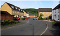
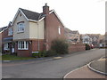
1
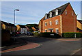
Michaelmas Close, Rogerstone
Viewed from Lobelia Close.
Image: © Jaggery
Taken: 17 May 2015
0.01 miles
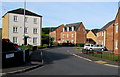
2
Lobelia Close, Rogerstone
Viewed from Lily Way. The street sign on the left shows an incorrect spelling Lobeilia.
Image: © Jaggery
Taken: 26 Feb 2010
0.01 miles
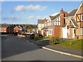
3
Lobelia Close leading to Michaelmas Close, Rogerstone
Looking along Lobelia Close from Lily Way. Michaelmas Close http://www.geograph.org.uk/photo/4478979 diverges on the left.
Image: © Jaggery
Taken: 17 May 2015
0.03 miles
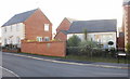
4
Foxglove Gardens, Afon Village, Rogerstone
One of the last areas to be developed on this large housing development on the site of the former Rogerstone power station.
Image: © Robin Drayton
Taken: 5 Feb 2009
0.03 miles
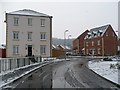
5
Lobelia Close, Rogerstone
From the corner of Michaelmas Close.
Image: © Jaggery
Taken: 17 May 2015
0.03 miles
6
What is Fuscia, Rogerstone
The spelling Fuscia is consistently shown on several signs in this area.
As the other street names are flowers, shrubs or trees, it looks like Fuchsia was intended, but the double error has been made official, it seems.
The current edition of the local AZ street atlas shows Fuscia, whereas the online Ordnance Survey map shows Fuschia (s and c in the wrong order) on part of the road, and Fuscia on another part.
Image: © Jaggery
Taken: 26 Feb 2010
0.05 miles
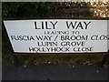
7
Lily Way, Rogerstone
The 47 houses on Lily Way were built c2004.
Image: © Jaggery
Taken: 26 Feb 2010
0.05 miles
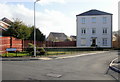
8
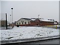
Rivermead Centre, Afon Village, Rogerstone
Image: © Robin Drayton
Taken: 5 Feb 2009
0.06 miles
9
Cornflower Close, Rogerstone
Viewed from Lily Way. The houses were built in 2004.
Image: © Jaggery
Taken: 26 Feb 2010
0.07 miles
10
Lupin Way, Rogerstone
Viewed from the corner of Fuscia Way. See http://www.geograph.org.uk/photo/1727457
for a comment about the (mis)spelling Fuscia.
Image: © Jaggery
Taken: 26 Feb 2010
0.07 miles