IMAGES TAKEN NEAR TO
Narcissus Grove, NEWPORT, NP10 9LP
Introduction
This page details the photographs taken nearby to Narcissus Grove, NP10 9LP by members of the Geograph project.
The Geograph project started in 2005 with the aim of publishing, organising and preserving representative images for every square kilometre of Great Britain, Ireland and the Isle of Man.

There are currently over 7.5m images from over14,400 individuals and you can help contribute to the project by visiting https://www.geograph.org.uk
Image Map
Images are licensed for reuse under creativecommons.org/licenses/by-sa/2.0
Notes
- Clicking on the map will re-center to the selected point.
- The higher the marker number, the further away the image location is from the centre of the postcode.
Image Listing (139 Images Found)
Images are licensed for reuse under creativecommons.org/licenses/by-sa/2.0
Image
Details
Distance
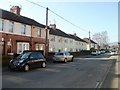
1
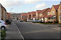
Narcissus Grove, Rogerstone
The view from the far end of Narcissus Grove. The houses were built in 2005.
Image: © Jaggery
Taken: 26 Feb 2010
0.04 miles
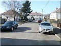
2
Courtfield Close, Rogerstone
Viewed from the edge of Court Gardens.
Image: © Jaggery
Taken: 4 Mar 2011
0.05 miles
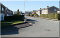
3
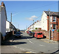
Far end of Church Street, Rogerstone
Church Street is a 230-metre long cul-de-sac connecting with St John's Crescent.
Image: © Jaggery
Taken: 4 Mar 2011
0.08 miles
4
The far end of Lily Way, Rogerstone
Houses on the west side of Lily Way, looking towards the far end of the street,
which is near, but does not connect with, the A467.
Image: © Jaggery
Taken: 26 Feb 2010
0.09 miles
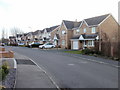
5
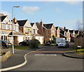
Southern side of Oak Road, Rogerstone
Examples of minimalist architecture viewed from near the NW end of Park Avenue.
Image: © Jaggery
Taken: 4 Mar 2011
0.09 miles
6
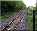
Railway SE from Rogerstone railway station
Viewed in mid May 2015. When the line to Ebbw Vale was reopened to passenger traffic in 2008, the intention was that trains would run from Rogerstone direct to both Newport station and Cardiff Central station. However, until some sections of track to Newport are replaced or updated, the only way to travel by train from here to Newport (a distance of a few kilometres) is via Cardiff, an indirect route of about 30 kilometres.
Image: © Jaggery
Taken: 17 May 2015
0.10 miles
7
![Alongside the river [7]](https://s1.geograph.org.uk/geophotos/01/81/63/1816309_66c71726_120x120.jpg)
Alongside the river [7]
Seen, across the field, from the footpath on the bank of the Ebbw River, is the dual carriageway A467 road and the houses of Fuscia Way.
Image: © Michael Dibb
Taken: 10 Mar 2010
0.10 miles
8
Broom Close, Rogerstone
Houses on the east side of Broom Close, viewed from Fuscia Way. See http://www.geograph.org.uk/photo/1727457 for comments about the (mis)spelling Fuscia.
Image: © Jaggery
Taken: 26 Feb 2010
0.11 miles
9
Church Street, Rogerstone
Looking along Church Street from the corner of St John's Crescent
Image: © Jaggery
Taken: 12 Oct 2009
0.12 miles
10
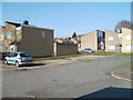
Houses and flats, Park Avenue, Rogerstone
Park Avenue is a cul-de-sac connecting with St John's Crescent. Roughly three-quarters of the buildings are houses. The white buildings (at the far end of the avenue) are flats.
Image: © Jaggery
Taken: 4 Mar 2011
0.12 miles