IMAGES TAKEN NEAR TO
Tulip Walk, NEWPORT, NP10 9LF
Introduction
This page details the photographs taken nearby to Tulip Walk, NP10 9LF by members of the Geograph project.
The Geograph project started in 2005 with the aim of publishing, organising and preserving representative images for every square kilometre of Great Britain, Ireland and the Isle of Man.

There are currently over 7.5m images from over14,400 individuals and you can help contribute to the project by visiting https://www.geograph.org.uk
Image Map
Images are licensed for reuse under creativecommons.org/licenses/by-sa/2.0
Notes
- Clicking on the map will re-center to the selected point.
- The higher the marker number, the further away the image location is from the centre of the postcode.
Image Listing (70 Images Found)
Images are licensed for reuse under creativecommons.org/licenses/by-sa/2.0
Image
Details
Distance
1
Iris Road, Rogerstone
Iris Road curves away from Fuscia Way.
See http://www.geograph.org.uk/photo/1727457 for a comment about the (mis)spelling Fuscia.
Image: © Jaggery
Taken: 26 Feb 2010
0.03 miles
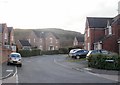
2
Tulip Walk, Rogerstone
Viewed from Fuscia Way.
See http://www.geograph.org.uk/photo/1727457 for a comment about the (mis)spelling Fuscia.
Image: © Jaggery
Taken: 26 Feb 2010
0.03 miles
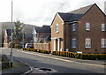
3
Apartment building, Fuscia Way, Rogerstone
Located on Fuscia Way, between Acer Way and Tulip Walk.
See http://www.geograph.org.uk/photo/1727457 for a comment about the (mis)spelling Fuscia.
Image: © Jaggery
Taken: 26 Feb 2010
0.03 miles
4
![River bridge [5]](https://s1.geograph.org.uk/geophotos/01/81/63/1816301_2907d600_120x120.jpg)
River bridge [5]
Seen from the footbridge, this modern bridge carries the main A467 road.
Image: © Michael Dibb
Taken: 10 Mar 2010
0.04 miles
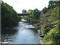
5
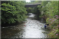
A467 bridge over River Ebbw
Looking downstream from a footbridge near Rogerstone.
Image: © M J Roscoe
Taken: 10 Jul 2017
0.04 miles
6
![Alongside the river [4]](https://s3.geograph.org.uk/geophotos/01/81/63/1816303_cce10f3c_120x120.jpg)
Alongside the river [4]
The river bank footpath is carried under the A467 road. The footbridge adjacent to the river monitoring station is visible.
Image: © Michael Dibb
Taken: 10 Mar 2010
0.05 miles
7
River Ebbw
The road bridge is the A467, Risca bypass. The photo was taken from the nearby foot bridge.
Image: © Robin Drayton
Taken: 6 Aug 2007
0.05 miles
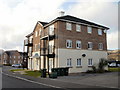
8
Rivermead Community Centre, Rogerstone
Located on the corner of Rivermead Way and Fuscia Way.
See http://www.geograph.org.uk/photo/1727457 for a comment about the (mis)spelling Fuscia.
Image: © Jaggery
Taken: 26 Feb 2010
0.06 miles
9
![Alongside the river [3]](https://s0.geograph.org.uk/geophotos/01/81/63/1816300_69098756_120x120.jpg)
Alongside the river [3]
Seen from the footbridge is this river monitoring station operated by the Environment Agency.
Image: © Michael Dibb
Taken: 10 Mar 2010
0.06 miles
10
![River bridge [4]](https://s2.geograph.org.uk/geophotos/01/81/62/1816298_60579790_120x120.jpg)
River bridge [4]
This well worn footbridge crosses the Ebbw River just north of the A467 road crossing.
Image: © Michael Dibb
Taken: 10 Mar 2010
0.06 miles