IMAGES TAKEN NEAR TO
Mulberry Close, NEWPORT, NP10 9JS
Introduction
This page details the photographs taken nearby to Mulberry Close, NP10 9JS by members of the Geograph project.
The Geograph project started in 2005 with the aim of publishing, organising and preserving representative images for every square kilometre of Great Britain, Ireland and the Isle of Man.

There are currently over 7.5m images from over14,400 individuals and you can help contribute to the project by visiting https://www.geograph.org.uk
Image Map
Images are licensed for reuse under creativecommons.org/licenses/by-sa/2.0
Notes
- Clicking on the map will re-center to the selected point.
- The higher the marker number, the further away the image location is from the centre of the postcode.
Image Listing (83 Images Found)
Images are licensed for reuse under creativecommons.org/licenses/by-sa/2.0
Image
Details
Distance
1
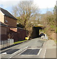
Railway bridge, Rivermead Way, Rogerstone
Rivermead Way passes under the 15 feet 6 inches (4.7 metres) headroom railway bridge. On the other side of the bridge, the road bends 90 degrees to the left.
Image: © Jaggery
Taken: 26 Feb 2010
0.04 miles
2

Sharp bend, Rivermead Way, Rogerstone
At the end of a long, straight descent http://www.geograph.org.uk/photo/1727293 from Risca Road, Rivermead Way makes a 90-degree turn to the right as it approaches a railway bridge. http://www.geograph.org.uk/photo/1727320
Image: © Jaggery
Taken: 26 Feb 2010
0.04 miles
3

Long straight descent, Rivermead Way, Rogerstone
Rivermead Way descends from Risca Road. It runs straight as an arrow for about 300 metres, then bends very sharply to the right http://www.geograph.org.uk/photo/1727298 as it passes underneath a railway bridge.
Image: © Jaggery
Taken: 26 Feb 2010
0.04 miles
4
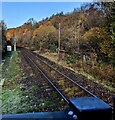
Single-track railway NW of Rogerstone station, Newport
Next station ahead is Risca & Pontymister.
Image: © Jaggery
Taken: 8 Dec 2022
0.04 miles
5
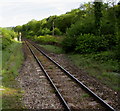
Railway from Rogerstone station towards Risca & Pontymister station
Rogerstone station opened for passenger services on February 6th 2008, when the northern terminus was Ebbw Vale Parkway. Today, Sunday May 17th 2015, sees the opening of a c3 km extension of the line to the new northern terminus station, Ebbw Vale Town.
Image: © Jaggery
Taken: 17 May 2015
0.04 miles
6
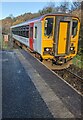
153914 leaving Rogerstone station, Newport
Transport for Wales Class 153 single-coach train from Newport to Cross Keys on December 8th 2022.
Image: © Jaggery
Taken: 8 Dec 2022
0.05 miles
7
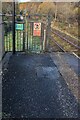
Notices at the NW end of Rogerstone station, Newport
In December 2022 a Samaritans notice is on the left.
A notice showing "Passengers must not cross the line"
and the Welsh equivalent is on the right.
Image: © Jaggery
Taken: 8 Dec 2022
0.05 miles
8
What is Fuscia, Rogerstone
The spelling Fuscia is consistently shown on several signs in this area.
As the other street names are flowers, shrubs or trees, it looks like Fuchsia was intended, but the double error has been made official, it seems.
The current edition of the local AZ street atlas shows Fuscia, whereas the online Ordnance Survey map shows Fuschia (s and c in the wrong order) on part of the road, and Fuscia on another part.
Image: © Jaggery
Taken: 26 Feb 2010
0.06 miles
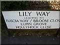
9
Lily Way, Rogerstone
The 47 houses on Lily Way were built c2004.
Image: © Jaggery
Taken: 26 Feb 2010
0.06 miles
10
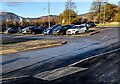
Railway station car park, Rogerstone, Newport
Accessed from Lily Way. The entrance to Rogerstone station is behind the camera
Image: © Jaggery
Taken: 8 Dec 2022
0.07 miles