IMAGES TAKEN NEAR TO
Oak Tree Drive, NEWPORT, NP10 9JN
Introduction
This page details the photographs taken nearby to Oak Tree Drive, NP10 9JN by members of the Geograph project.
The Geograph project started in 2005 with the aim of publishing, organising and preserving representative images for every square kilometre of Great Britain, Ireland and the Isle of Man.

There are currently over 7.5m images from over14,400 individuals and you can help contribute to the project by visiting https://www.geograph.org.uk
Image Map
Images are licensed for reuse under creativecommons.org/licenses/by-sa/2.0
Notes
- Clicking on the map will re-center to the selected point.
- The higher the marker number, the further away the image location is from the centre of the postcode.
Image Listing (71 Images Found)
Images are licensed for reuse under creativecommons.org/licenses/by-sa/2.0
Image
Details
Distance
1
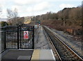
The view northwestwards from Rogerstone railway station
The next stop in this direction is at Risca & Pontymister station.
Rogerstone station opened for passenger service on February 6th 2008.
Image: © Jaggery
Taken: 26 Feb 2010
0.07 miles
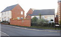
2

Houses on Risca Road, Rogerstone
Houses on the north side of Risca Road.
A short distance ahead is the turning for Rivermead Way, which leads to Rogerstone railway station.
Image: © Jaggery
Taken: 26 Feb 2010
0.07 miles
3
![Alongside the river [2]](https://s0.geograph.org.uk/geophotos/01/81/45/1814572_a853bbf6_120x120.jpg)
Alongside the river [2]
The footpath continues to pass along the bank of the Ebbw River. This view is looking north west.
Image: © Michael Dibb
Taken: 10 Mar 2010
0.09 miles
4

Risca Road Rogerstone approaching the turning for Rivermead Way
The turning for Rivermead Way, and Rogerstone railway station, is a little ahead, on the left.
Image: © Jaggery
Taken: 26 Feb 2010
0.09 miles
5
![River bridge [3]](https://s0.geograph.org.uk/geophotos/01/81/45/1814584_4ca456c2_120x120.jpg)
River bridge [3]
The bridge carrying Rivermead Way over the Ebbw River did not allow the footpath to continue on the bank. Walkers are required to ascend to the road to cross it and then to descend to the river bank again. This view is from Rivermead Way looking towards the recently re-built Rogerstone railway station.
Image: © Michael Dibb
Taken: 10 Mar 2010
0.09 miles
6
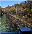
Single-track railway NW of Rogerstone station, Newport
Next station ahead is Risca & Pontymister.
Image: © Jaggery
Taken: 8 Dec 2022
0.11 miles
7

Bungalows on Risca Road, Rogerstone
Bungalows on the north side of Risca Road.
A short distance ahead is the turning for Rivermead Way, which leads to Rogerstone railway station
Image: © Jaggery
Taken: 26 Feb 2010
0.11 miles
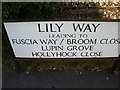
8
Lily Way, Rogerstone
The 47 houses on Lily Way were built c2004.
Image: © Jaggery
Taken: 26 Feb 2010
0.11 miles
9
What is Fuscia, Rogerstone
The spelling Fuscia is consistently shown on several signs in this area.
As the other street names are flowers, shrubs or trees, it looks like Fuchsia was intended, but the double error has been made official, it seems.
The current edition of the local AZ street atlas shows Fuscia, whereas the online Ordnance Survey map shows Fuschia (s and c in the wrong order) on part of the road, and Fuscia on another part.
Image: © Jaggery
Taken: 26 Feb 2010
0.11 miles
10
![River bridge [2]](https://s2.geograph.org.uk/geophotos/01/81/45/1814578_24abbf91_120x120.jpg)
River bridge [2]
This modern bridge carries Rivermead Way over the Ebbw River.
Image: © Michael Dibb
Taken: 10 Mar 2010
0.12 miles