IMAGES TAKEN NEAR TO
Phillips Green, NEWPORT, NP10 9HR
Introduction
This page details the photographs taken nearby to Phillips Green, NP10 9HR by members of the Geograph project.
The Geograph project started in 2005 with the aim of publishing, organising and preserving representative images for every square kilometre of Great Britain, Ireland and the Isle of Man.

There are currently over 7.5m images from over14,400 individuals and you can help contribute to the project by visiting https://www.geograph.org.uk
Image Map
Images are licensed for reuse under creativecommons.org/licenses/by-sa/2.0
Notes
- Clicking on the map will re-center to the selected point.
- The higher the marker number, the further away the image location is from the centre of the postcode.
Image Listing (44 Images Found)
Images are licensed for reuse under creativecommons.org/licenses/by-sa/2.0
Image
Details
Distance
1
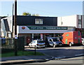
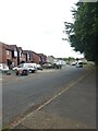
Thornbury Park Post Office and Stores, Rogerstone
Located on Ebenezer Drive.
Image: © Jaggery
Taken: 12 Oct 2009
0.08 miles
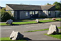
2
Rogerstone & Cefn Wood Bowls Clubs
Located adjacent to the police station.
Image: © Jaggery
Taken: 12 Oct 2009
0.10 miles
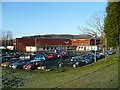
3
Rogerstone Police Station
Located on Ebenezer Drive.
Image: © Jaggery
Taken: 12 Oct 2009
0.10 miles
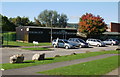
4
Rogerstone Primary School
This school was opened in 2006 following the destruction of the previous school by fire.
The building is eco-friendly with sedum plants on the roof, solar panels and the use of rainwater as “grey water” to flush the toilets.
Image: © Robin Drayton
Taken: 10 Dec 2008
0.11 miles
6

Cefn Wood Baptist Church, Rogerstone
Located on Ebenezer Drive.
Image: © Jaggery
Taken: 12 Oct 2009
0.12 miles
7
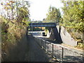
Rogerstone Bypass railway bridge
Officially named Rogerstone Bypass bridge 2m 56c WVL , the bridge actually crosses Ebenezer Drive, but Rogerstone Bypass (A467) is only a few metres away, on the far side of the bridge.
Image: © Jaggery
Taken: 12 Oct 2009
0.12 miles
8
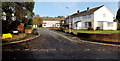
Tregwilym Close, Rogerstone, Newport
Viewed across Tregwilym Road looking along Tregwilym Close towards Tregwilym Walk.
Image: © Jaggery
Taken: 14 Nov 2013
0.13 miles
9
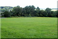
SE edge of Cefn Wood, Rogerstone
Viewed from near the edge of the turning area http://www.geograph.org.uk/photo/2829418 at the NW end of High Cross Drive.
Image: © Jaggery
Taken: 8 Aug 2011
0.14 miles
10
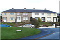
Tudor Crescent, High Cross, Newport
Tudor Crescent houses viewed from near the corner of Hillside Crescent.
Image: © Jaggery
Taken: 18 Nov 2010
0.15 miles