IMAGES TAKEN NEAR TO
Bala Drive, NEWPORT, NP10 9HN
Introduction
This page details the photographs taken nearby to Bala Drive, NP10 9HN by members of the Geograph project.
The Geograph project started in 2005 with the aim of publishing, organising and preserving representative images for every square kilometre of Great Britain, Ireland and the Isle of Man.

There are currently over 7.5m images from over14,400 individuals and you can help contribute to the project by visiting https://www.geograph.org.uk
Image Map
Images are licensed for reuse under creativecommons.org/licenses/by-sa/2.0
Notes
- Clicking on the map will re-center to the selected point.
- The higher the marker number, the further away the image location is from the centre of the postcode.
Image Listing (53 Images Found)
Images are licensed for reuse under creativecommons.org/licenses/by-sa/2.0
Image
Details
Distance
1
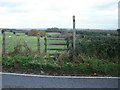
Stile , Cwm Lane
The stile gives access from Cwm Lane to a public right of way (as stated on the notice on the post on the right) that runs northeastwards alongside a field hedge.
Image: © Jaggery
Taken: 19 Nov 2009
0.03 miles
2
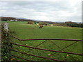
Sheep grazing, Cwm Farm
The view from the edge of Cwm Lane across a field close to Cwm Farm.
Image: © Jaggery
Taken: 19 Nov 2009
0.08 miles
3
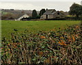
Edge of Cwm Farm from Cwm Lane
The view towards Cwm Farm from a substantial hedge on the edge of Cwm Lane.
Image: © Jaggery
Taken: 19 Nov 2009
0.09 miles
5

Tree-lined school entrance gates, Rogerstone, Newport
Viewed across Ruskin Avenue towards Mount Pleasant Primary School in January 2014.
On Thursday September 4th 2014, the school featured in the world media and on the front page of the White House website after it was briefly visited by US President Barack Obama, along with British Prime Minister David Cameron. Later that day, both men went to the NATO summit being held at the Celtic Manor a few kilometres to the east. The visit was the result of a letter sent to the White House and an appeal on Twitter sent by the Deputy Headmaster.
Image: © Jaggery
Taken: 23 Jan 2014
0.10 miles
6
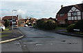
Llangorse Drive, Rogerstone, Newport
Viewed across Bala Drive. This is the NW junction of the two roads.
They meet again about 350 metres to the SE.
Image: © Jaggery
Taken: 23 Jan 2014
0.12 miles
7
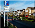
Traffic calming on Ruskin Avenue, Rogerstone, Newport
Viewed from the corner of Hunter Close. http://www.geograph.org.uk/photo/3909168 For a few metres, the road narrows to the width of one vehicle. Vehicles on this side have priority over oncoming vehicles. The 30mph speed limit ahead reduces to 20mph on this side, on the approach to the entrance http://www.geograph.org.uk/photo/3909096 to Mount Pleasant Primary School.
Image: © Jaggery
Taken: 23 Jan 2014
0.13 miles
8
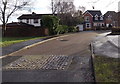
Groes Close, Rogerstone, Newport
Viewed from the Groes Road end, near this http://www.geograph.org.uk/photo/3944328 roundabout.
Image: © Jaggery
Taken: 23 Jan 2014
0.14 miles
9
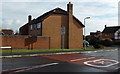
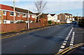
20 to 30 along Bala Drive, Rogerstone, Newport
The 20mph speed limit along Groes Road http://www.geograph.org.uk/photo/3943930 increases to 30mph.
Image: © Jaggery
Taken: 23 Jan 2014
0.14 miles
10
Ruskin Avenue houses, Rogerstone, Newport
Ruskin Avenue is the main road through the Mount Pleasant area of Rogerstone.
This view is towards the Stevenson Close junction, out of shot ahead.
Image: © Jaggery
Taken: 23 Jan 2014
0.15 miles