IMAGES TAKEN NEAR TO
Pontymason Court, NEWPORT, NP10 9HF
Introduction
This page details the photographs taken nearby to Pontymason Court, NP10 9HF by members of the Geograph project.
The Geograph project started in 2005 with the aim of publishing, organising and preserving representative images for every square kilometre of Great Britain, Ireland and the Isle of Man.

There are currently over 7.5m images from over14,400 individuals and you can help contribute to the project by visiting https://www.geograph.org.uk
Image Map
Images are licensed for reuse under creativecommons.org/licenses/by-sa/2.0
Notes
- Clicking on the map will re-center to the selected point.
- The higher the marker number, the further away the image location is from the centre of the postcode.
Image Listing (75 Images Found)
Images are licensed for reuse under creativecommons.org/licenses/by-sa/2.0
Image
Details
Distance
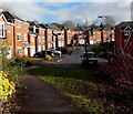
1
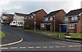
Pontymason Court houses, Rogerstone, Newport
Houses on the south side of Pontymason Court, viewed from Pontymason Lane.
Image: © Jaggery
Taken: 22 Jan 2014
0.02 miles
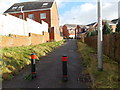
2
Metal posts across the western end of Great Oaks Park, Rogerstone, Newport
Viewed from Pontymason Lane. Walkers and cyclists can pass through, but not cars or lorries.
Image: © Jaggery
Taken: 22 Jan 2014
0.04 miles
3
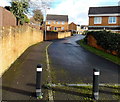
Pontymason Court, Rogerstone, Newport
Pontymason Court (leading to Pontymason Close) climbs away from Pontymason Lane.
Image: © Jaggery
Taken: 22 Jan 2014
0.05 miles
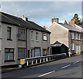
4
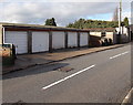
Lockup garages, Pontymason Lane, Rogerstone, Newport
Pontymason Lane is partly in Rogerstone (City of Newport) and partly in Risca
(County Borough of Caerphilly). This SE section is in Rogerstone.
Image: © Jaggery
Taken: 22 Jan 2014
0.07 miles
5
No 4-wheel vehicular access here to Pontymason Rise, Rogerstone, Newport
Metal posts block across from Pontymason Lane on the camera side to Pontymason Rise.
Image: © Jaggery
Taken: 22 Jan 2014
0.07 miles
6
Yellow and black warnings alongside Pontymason Lane, Rogerstone, Newport
Yellow and black markings on wasps and hornets warn of a painful sting.
Similar colours here draw attention to roadside metal barriers.
Image: © Jaggery
Taken: 22 Jan 2014
0.08 miles
7
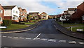
Pontymason Rise, Rogerstone, Newport
Viewed from Pontymason Lane.
Image: © Jaggery
Taken: 22 Jan 2014
0.10 miles
8
No motorcycles or horses allowed on this cycle route in Rogerstone, Newport
Looking east from Pontymason Lane. The green sign is alongside National Cycle Network route 47 along the former towpath of the disused Monmouthshire and Brecon canal (Crumlin Arm).
Image: © Jaggery
Taken: 22 Jan 2014
0.12 miles
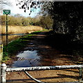
9
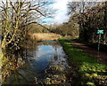
Disused canal east of Pontymason Lane, Rogerstone, Newport
Part of the disused Monmouthshire and Brecon canal (Crumlin Arm).
Image: © Jaggery
Taken: 22 Jan 2014
0.13 miles
10
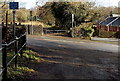
Cyclists dismount at Pontymason Lane, Rogerstone, Newport
The sign is at the point where Pontymason Lane crosses National Cycle Network route 47 which uses the former towpath alongside the disused Monmouthshire and Brecon canal (Crumlin Arm).
I doubt that many cyclists do dismount (why should they?) so better wording on the sign would be Cyclists stop and look both ways.
Image: © Jaggery
Taken: 22 Jan 2014
0.13 miles