IMAGES TAKEN NEAR TO
Rogerstone, NEWPORT, NP10 9GL
Introduction
This page details the photographs taken nearby to NP10 9GL by members of the Geograph project.
The Geograph project started in 2005 with the aim of publishing, organising and preserving representative images for every square kilometre of Great Britain, Ireland and the Isle of Man.

There are currently over 7.5m images from over14,400 individuals and you can help contribute to the project by visiting https://www.geograph.org.uk
Image Map
Images are licensed for reuse under creativecommons.org/licenses/by-sa/2.0
Notes
- Clicking on the map will re-center to the selected point.
- The higher the marker number, the further away the image location is from the centre of the postcode.
Image Listing (62 Images Found)
Images are licensed for reuse under creativecommons.org/licenses/by-sa/2.0
Image
Details
Distance
1
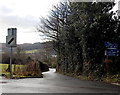
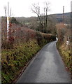
No track laying vehicles ahead from Pontymason Lane
A narrow road descends from Pontymason Lane towards the B4591. Signs on the right show
No track laying vehicles and a 4 tonnes axle weight limit 200 yards ahead (across a canal bridge).
It is a curious feature of British road speed limits that the much wider Pontymason Lane in the foreground has a 30mph speed limit whereas this narrow road, little more than the width of a car,
has a speed limit for most vehicles of 60mph...
Image: © Jaggery
Taken: 22 Jan 2014
0.01 miles
2
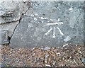
Ordnance Survey Cut Mark
This OS cut mark can be found on the wall of Derwallt Cottage. It marks a point 100.050m above mean sea level.
Image: © Adrian Dust
Taken: 11 May 2019
0.01 miles
3
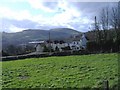
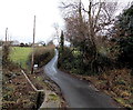
Dewallt
A narrow lane runs downhill towards Pontymister, past this group of cottages, from Pontymason Lane.
Image: © Roger Cornfoot
Taken: 1 Mar 2007
0.02 miles
4

Pontymason Road signs on the approach to a mini-roundabout, Risca
Looking towards this http://www.geograph.org.uk/photo/4242459 mini-roundabout.
Image: © Jaggery
Taken: 22 Jan 2014
0.03 miles
5

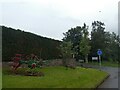
Pontymason Lane mini-roundabout, Risca
Pointing right away from Pontymason Lane, the brown sign shows Leisure centre.
Image: © Jaggery
Taken: 22 Jan 2014
0.03 miles
6
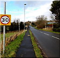
40 to 30 along Pontymason Lane
The 40mph speed limit along a rural section of Pontymason Lane
decreases to 30mph on the approach to a residential area.
Image: © Jaggery
Taken: 22 Jan 2014
0.03 miles
8
Lane from the canal to Pontymason Lane near Pontymister
Viewed from this http://www.geograph.org.uk/photo/3953187 bridge over the Crumlin arm of the Monmouthshire & Brecon Canal.
Image: © Jaggery
Taken: 22 Jan 2014
0.04 miles
9
Gas pipeline marker near Pontymister
Alongside a narrow road from Pontymason Lane to the B4591, a white pole on the left marks the location of a gas pipeline under the road. The pole shows the phone number to ring before excavating.
Image: © Jaggery
Taken: 22 Jan 2014
0.05 miles
10

Old anchor outside The Oaklands, Risca
Viewed across Pontymason Lane. The anchor is on the left. An old agricultural machine is on the right.
Image: © Jaggery
Taken: 22 Jan 2014
0.06 miles