IMAGES TAKEN NEAR TO
Risca Road, NEWPORT, NP10 9GD
Introduction
This page details the photographs taken nearby to Risca Road, NP10 9GD by members of the Geograph project.
The Geograph project started in 2005 with the aim of publishing, organising and preserving representative images for every square kilometre of Great Britain, Ireland and the Isle of Man.

There are currently over 7.5m images from over14,400 individuals and you can help contribute to the project by visiting https://www.geograph.org.uk
Image Map
Images are licensed for reuse under creativecommons.org/licenses/by-sa/2.0
Notes
- Clicking on the map will re-center to the selected point.
- The higher the marker number, the further away the image location is from the centre of the postcode.
Image Listing (38 Images Found)
Images are licensed for reuse under creativecommons.org/licenses/by-sa/2.0
Image
Details
Distance
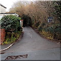
1

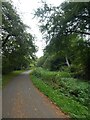
Risca Road Rogerstone approaching the turning for Rivermead Way
The turning for Rivermead Way, and Rogerstone railway station, is a little ahead, on the left.
Image: © Jaggery
Taken: 26 Feb 2010
0.08 miles
2
![River bridge [1]](https://s0.geograph.org.uk/geophotos/01/81/45/1814568_d5d831fe_120x120.jpg)
River bridge [1]
A well maintained footbridge over the Ebbw River. The bridge connects Cedar Wood Drive on the east bank with Jasmine Close on the west bank.
Image: © Michael Dibb
Taken: 10 Mar 2010
0.10 miles
3
Shared use path by Monmouthshire and Brecon Canal
Image: © David Smith
Taken: 25 Sep 2021
0.11 miles
4
![Alongside the river [1]](https://s2.geograph.org.uk/geophotos/01/81/45/1814550_d319c1de_120x120.jpg)
Alongside the river [1]
The footpath has come from the canal, crossed Risca Road and the railway and now runs along the bank of the Ebbw River.
Image: © Michael Dibb
Taken: 10 Mar 2010
0.12 miles
5

Bungalows on Risca Road, Rogerstone
Bungalows on the north side of Risca Road.
A short distance ahead is the turning for Rivermead Way, which leads to Rogerstone railway station
Image: © Jaggery
Taken: 26 Feb 2010
0.12 miles
6
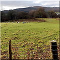
Grazing sheep near Pontymason Lane
Viewed from Pontymason Lane looking towards trees lining the Monmouthshire & Brecon Canal.
Image: © Jaggery
Taken: 22 Jan 2014
0.13 miles
7
![Alongside the river [2]](https://s0.geograph.org.uk/geophotos/01/81/45/1814572_a853bbf6_120x120.jpg)
Alongside the river [2]
The footpath continues to pass along the bank of the Ebbw River. This view is looking north west.
Image: © Michael Dibb
Taken: 10 Mar 2010
0.14 miles
8
Across Risca Road
The track from the canal meets Risca Road and continues down towards the railway and Ebbw River.
Image: © Michael Dibb
Taken: 10 Mar 2010
0.14 miles
9
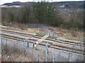
Across the railway
The footpath crosses the railway on its way down to the Ebbw River. When the railway was doubled at this spot and upgraded to carry passengers again, the crossing point has been similarly upgraded with new fencing.
Image: © Michael Dibb
Taken: 10 Mar 2010
0.14 miles
10
Lane to the canal, Rogerstone
Heading north away from the B4591 Risca Road towards the Crumlin arm of the Monmouthshire & Brecon Canal.
Image: © Jaggery
Taken: 22 Jan 2014
0.16 miles