IMAGES TAKEN NEAR TO
Church Street, NEWPORT, NP10 9FP
Introduction
This page details the photographs taken nearby to Church Street, NP10 9FP by members of the Geograph project.
The Geograph project started in 2005 with the aim of publishing, organising and preserving representative images for every square kilometre of Great Britain, Ireland and the Isle of Man.

There are currently over 7.5m images from over14,400 individuals and you can help contribute to the project by visiting https://www.geograph.org.uk
Image Map
Images are licensed for reuse under creativecommons.org/licenses/by-sa/2.0
Notes
- Clicking on the map will re-center to the selected point.
- The higher the marker number, the further away the image location is from the centre of the postcode.
Image Listing (138 Images Found)
Images are licensed for reuse under creativecommons.org/licenses/by-sa/2.0
Image
Details
Distance
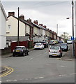
1
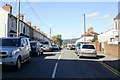
Park Avenue, Rogerstone
Viewed from the corner of St John's Crescent.
Image: © Jaggery
Taken: 12 Oct 2009
0.02 miles
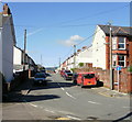
2
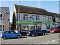
Rogerstone Post Office, Newport
Rogerstone Post Office is located in the Co-operative Food store on St John's Crescent.
Kelly's Directory of 1901 didn't state the location of Rogerstone Post Office at that date, but did record that the Rogerstone sub postmaster was George Hiley. He was also a boot & shoe maker and butcher.
Image: © Jaggery
Taken: 12 Oct 2009
0.02 miles
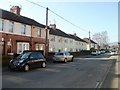
3
St John's Crescent houses, Rogerstone
Viewed from the corner of Oak Road. Just out of shot on the right are the turnings for The Uplands and, a few metres further on, for Wern Terrace.
Image: © Jaggery
Taken: 4 Mar 2011
0.02 miles
4
Park Avenue, Rogerstone viewed from Oak Road
The NE side of Park Avenue viewed from the edge of Oak Road http://www.geograph.org.uk/photo/2317873 looking in the direction of St John's Crescent. The white buildings are flats, with houses beyond.
Image: © Jaggery
Taken: 4 Mar 2011
0.02 miles
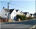
5
Church Street, Rogerstone, Newport
Viewed from St John's Crescent. Church Street is a dead end street extending for about 220 metres.
Image: © Jaggery
Taken: 20 Apr 2017
0.04 miles
6
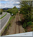
Ebbw Valley Railway towards Rogerstone railway station
Viewed from this https://www.geograph.org.uk/photo/5759897 bridge. Here single track, the Ebbw Valley Railway heads north towards Rogerstone station https://www.geograph.org.uk/photo/1727498 on the route to Ebbw Vale. The dual carriageway A467 is on the left.
Image: © Jaggery
Taken: 1 May 2018
0.04 miles
7
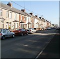
Church Street, Rogerstone
Looking along Church Street from the corner of St John's Crescent
Image: © Jaggery
Taken: 12 Oct 2009
0.04 miles
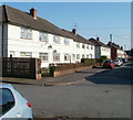
8
Houses and flats, Park Avenue, Rogerstone
Park Avenue is a cul-de-sac connecting with St John's Crescent. Roughly three-quarters of the buildings are houses. The white buildings (at the far end of the avenue) are flats.
Image: © Jaggery
Taken: 4 Mar 2011
0.04 miles
9
SW side of Church Street, Rogerstone
Viewed from the far end of the cul-de-sac, looking towards St John's Crescent.
Image: © Jaggery
Taken: 4 Mar 2011
0.04 miles
10
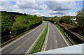
A467 from Rogerstone towards Pontymister
Viewed from this https://www.geograph.org.uk/photo/5759897 bridge. The Ebbw Valley Railway https://www.geograph.org.uk/photo/5759947 is on the right.
Image: © Jaggery
Taken: 1 May 2018
0.05 miles