IMAGES TAKEN NEAR TO
The Uplands, NEWPORT, NP10 9FE
Introduction
This page details the photographs taken nearby to The Uplands, NP10 9FE by members of the Geograph project.
The Geograph project started in 2005 with the aim of publishing, organising and preserving representative images for every square kilometre of Great Britain, Ireland and the Isle of Man.

There are currently over 7.5m images from over14,400 individuals and you can help contribute to the project by visiting https://www.geograph.org.uk
Image Map
Images are licensed for reuse under creativecommons.org/licenses/by-sa/2.0
Notes
- Clicking on the map will re-center to the selected point.
- The higher the marker number, the further away the image location is from the centre of the postcode.
Image Listing (169 Images Found)
Images are licensed for reuse under creativecommons.org/licenses/by-sa/2.0
Image
Details
Distance
1
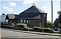
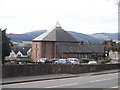
Bethesda Baptist Church, Rogerstone
Located on Cefn Road, near the Great Oaks Park roundabout.
The nameplate on the front of this modern building states "Founded 1742". This refers to the building of the first Bethesda Baptist chapel in Rogerstone.
Image: © Jaggery
Taken: 12 Oct 2009
0.02 miles
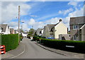
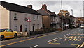
2
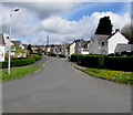
North along The Uplands, Rogerstone
The road named The Uplands ascends towards Cefn Road.
Image: © Jaggery
Taken: 1 May 2018
0.03 miles
3
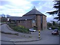
Bethesda Baptist Chapel
Bethesda Baptist Chapel, Rogerstone.
Image: © Alan Hughes
Taken: 11 May 2017
0.04 miles
4
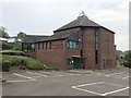
Bethesda Baptist Church, Rogerstone
A modern, 'drive-in' church.
Image: © Roger Cornfoot
Taken: 1 Mar 2007
0.04 miles
6
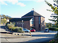
Bethesda Baptist Chapel, Rogerstone
The original building on this site was erected in 1742, rebuilt in 1843 and again in 1900.
This building dates from the 1990s.
Image: © Robin Drayton
Taken: 8 Nov 2019
0.05 miles
7
Ifor Hael Road, Rogerstone
Cul-de-sac on the north side of Wern Terrace. Ifor Hael (Ivor the Generous) was the name given by the 14th century Welsh poet Dafydd ap Gwilym to his chief patron, Ifor ap Llywelyn, a resident of nearby Bassaleg.
Image: © Jaggery
Taken: 1 May 2018
0.05 miles
8
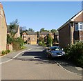
Acorn Close, Rogerstone
Viewed from Great Oaks Park. There are 32 houses in Acorn Close, built in 2002.
Image: © Jaggery
Taken: 12 Oct 2009
0.06 miles
9
Cefn Road houses, Rogerstone, Newport
Located between the Tredegar Arms http://www.geograph.org.uk/photo/3891986 behind the camera and Bethesda Baptist Church. http://www.geograph.org.uk/photo/1664707
Image: © Jaggery
Taken: 23 Jan 2014
0.06 miles
10
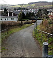
Groes Road descends to Cefn Road, Rogerstone, Newport
Viewed from near this http://www.geograph.org.uk/photo/3972753 bridge. Groes Road, formerly a through road for motor vehicles,
is now a footpath and cycle route, part of National Cycle Network route 47.
Image: © Jaggery
Taken: 23 Jan 2014
0.07 miles