IMAGES TAKEN NEAR TO
Tregwilym Road, NEWPORT, NP10 9EJ
Introduction
This page details the photographs taken nearby to Tregwilym Road, NP10 9EJ by members of the Geograph project.
The Geograph project started in 2005 with the aim of publishing, organising and preserving representative images for every square kilometre of Great Britain, Ireland and the Isle of Man.

There are currently over 7.5m images from over14,400 individuals and you can help contribute to the project by visiting https://www.geograph.org.uk
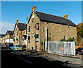
Image Map
Images are licensed for reuse under creativecommons.org/licenses/by-sa/2.0
Notes
- Clicking on the map will re-center to the selected point.
- The higher the marker number, the further away the image location is from the centre of the postcode.
Image Listing (63 Images Found)
Images are licensed for reuse under creativecommons.org/licenses/by-sa/2.0
Image
Details
Distance
1
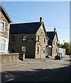
Indian Palace, Rogerstone
Indian cuisine restaurant and takeaway in Tregwilym Road. Viewed in mid November 2013.
A Google Earth Street View taken in July 2012 shows that it was the Mint Leaf.
This view http://www.geograph.org.uk/photo/1608315 from October 2009 shows The British Raj.
Image: © Jaggery
Taken: 14 Nov 2013
0.01 miles
2
Indian Palace, Rogerstone
Indian cuisine restaurant and takeaway in Tregwilym Road. Viewed in mid November 2013.
A Google Earth Street View taken in July 2012 shows that it was the Mint Leaf.
This view http://www.geograph.org.uk/photo/1608315 from October 2009 shows The British Raj.
The inscription in stone on the building is AD 1887.
Image: © Jaggery
Taken: 14 Nov 2013
0.03 miles
3
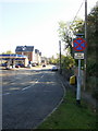
Tregwilym Road, Rogerstone
The view southeastwards along the southern loop of Tregwilym Road.
Image: © Jaggery
Taken: 12 Oct 2009
0.03 miles
4
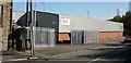
Saro Engineering Ltd, Rogerstone
Engineering factory at 66 Tregwilym Road. Saro are specialists in CNC (computer numerical controlled) machine tools, and servicing production line breakdowns.
Image: © Jaggery
Taken: 12 Oct 2009
0.03 miles
5
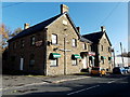
The British Raj, Rogerstone, Newport
On Tregilwym Road. Formerly pub premises, this large building
is occupied by The British Raj, an Indian restaurant.
Update. In mid November 2013 the restaurant was named Indian Palace. http://www.geograph.org.uk/photo/3821440
Image: © Jaggery
Taken: 12 Oct 2009
0.03 miles
6
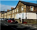
Row of stone houses, Tregwilym Road, Rogerstone
The sealed-up large window and corner location gives a clue to its former use as a commercial premises. In the late 1960s and early 1970s the premises was in use as Derek Pugh, Bookmakers.
Image: © Jaggery
Taken: 14 Nov 2013
0.04 miles
7
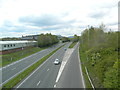
The A467 near Rogerstone, looking north-west
Image: © John Lord
Taken: 5 May 2012
0.05 miles
8
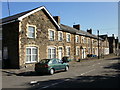
Terraced housing, Tregwilym Road, Rogerstone
Old and new contrast : these stone-built houses are next to modern brick-built flats http://www.geograph.org.uk/photo/1608218
Image: © Jaggery
Taken: 12 Oct 2009
0.05 miles
9
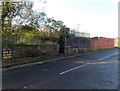
Remains of a railway bridge in Rogerstone, Newport
Viewed across Tregwilym Road opposite Saro. http://www.geograph.org.uk/photo/1608342
There used to be an industrial railway in this area.
Image: © Jaggery
Taken: 14 Nov 2013
0.06 miles
10
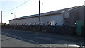
Disused former Alcan hall, Rogerstone, Newport
The 35 metre long building is alongside Tregwilym Road,
at the edge of a large site formerly occupied by Alcan (aluminium manufacturers).
Image: © Jaggery
Taken: 14 Nov 2013
0.07 miles