IMAGES TAKEN NEAR TO
Greenfield Road, NEWPORT, NP10 9BW
Introduction
This page details the photographs taken nearby to Greenfield Road, NP10 9BW by members of the Geograph project.
The Geograph project started in 2005 with the aim of publishing, organising and preserving representative images for every square kilometre of Great Britain, Ireland and the Isle of Man.

There are currently over 7.5m images from over14,400 individuals and you can help contribute to the project by visiting https://www.geograph.org.uk
Image Map
Images are licensed for reuse under creativecommons.org/licenses/by-sa/2.0
Notes
- Clicking on the map will re-center to the selected point.
- The higher the marker number, the further away the image location is from the centre of the postcode.
Image Listing (104 Images Found)
Images are licensed for reuse under creativecommons.org/licenses/by-sa/2.0
Image
Details
Distance
1
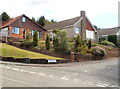
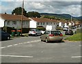
Tredegar Park View houses, Newport
Houses at the western end of the road, viewed across High Cross Lane from the edge of Greenfield Road.
Image: © Jaggery
Taken: 8 Aug 2011
0.02 miles
2
SE end of Ebenezer Drive, Newport
Viewed from the High Cross Lane end. Ebenezer Drive leads to Thornbury Park Estate and Cefn Wood Estate.
Image: © Jaggery
Taken: 8 Aug 2011
0.05 miles
3
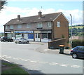
Greenfield Road shops, Newport
The three shops are at the SE end of Greenfield Road, on the corner of High Cross Lane.
From left to right: Bliss Nails & Beauty; Greenfield Stores (a Lifestyle Express store); Dimensions Unisex Salon.
Image: © Jaggery
Taken: 8 Aug 2011
0.05 miles
4
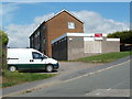
Retail premises to let, corner of High Cross Lane and Greenfield Road, Newport
Viewed across High Cross Lane. The building to let is in front of a row of three shops http://www.geograph.org.uk/photo/2546568 on the corner of Greenfield Road.
Image: © Jaggery
Taken: 8 Aug 2011
0.05 miles
5
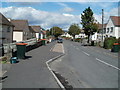
Newport : Greenfield Road houses viewed from Hillside Crescent
Image: © Jaggery
Taken: 8 Aug 2011
0.05 miles
6
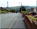
High Cross Lane, Newport
High Cross Lane descends towards Western Valley Road. In the distance is the eastern edge of Bassaleg and the hillside beyond.
Image: © Jaggery
Taken: 21 Jul 2011
0.05 miles
7
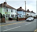
Light green and light blue, High Cross Lane, Newport
Two coloured houses stand out amid the general whiteness of neighbouring houses.
Image: © Jaggery
Taken: 21 Jul 2011
0.05 miles
8
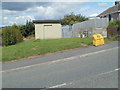
Former SWEPOC electricity substation, High Cross Lane, Newport
The small electricity substation set back from the west side of High Cross Lane is of historical interest. The inscription above the door is SWEPOC 1930.
SWEPOC (South Wales Electric Power Company) was one of more than 600 electric power companies in the UK that were nationalised into twelve Area Boards under the terms of the Electricity Act 1947. SWEPOC became part of SWALEB (South Wales Electricity Board), which was renamed SWALEC (South Wales Electricity) in 1990.
Image: © Jaggery
Taken: 8 Aug 2011
0.05 miles
10
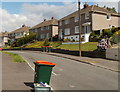
Wheely bin day, Hillside Crescent, Newport
Mondays are wheely bin emptying days in Hillside Crescent. The orange-lidded bins seen here are for garden trimmings and cardboard. They are emptied fortnightly.
The small green Recycle for Charity box in the foreground is for empty bottles, tins and plastic items. Newport households also have green-lidded wheely bins for rubbish that cannot be recycled. These bins are also emptied fortnightly, the week before and after the orange-lidded bins.
Image: © Jaggery
Taken: 8 Aug 2011
0.07 miles