IMAGES TAKEN NEAR TO
Granville Close, NEWPORT, NP10 9BP
Introduction
This page details the photographs taken nearby to Granville Close, NP10 9BP by members of the Geograph project.
The Geograph project started in 2005 with the aim of publishing, organising and preserving representative images for every square kilometre of Great Britain, Ireland and the Isle of Man.

There are currently over 7.5m images from over14,400 individuals and you can help contribute to the project by visiting https://www.geograph.org.uk
Image Map
Images are licensed for reuse under creativecommons.org/licenses/by-sa/2.0
Notes
- Clicking on the map will re-center to the selected point.
- The higher the marker number, the further away the image location is from the centre of the postcode.
Image Listing (93 Images Found)
Images are licensed for reuse under creativecommons.org/licenses/by-sa/2.0
Image
Details
Distance
1
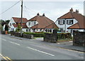
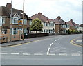
High Cross Lane houses, Newport
Six semi-detached houses viewed from opposite the High Cross Drive http://www.geograph.org.uk/photo/2534999 turning. The houses on the left face Church Close.
Image: © Jaggery
Taken: 21 Jul 2011
0.03 miles
2
Tudor Crescent, Newport
This view of Tudor Crescent from the High Cross Drive end shows a straight road - most uncrescentlike! However, it follows a more crescentlike shape ahead, starting at a 90 degree bend at the corner of Granville Close, just out of shot.
Image: © Jaggery
Taken: 8 Aug 2011
0.04 miles
3

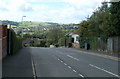
Eastern end of High Cross Drive, Newport
Viewed from the corner of High Cross Lane. Out of shot around the bend on the right is High Cross Primary School.
Image: © Jaggery
Taken: 21 Jul 2011
0.05 miles
4
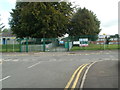
Entrance to High Cross Primary School, Newport
Viewed from Tudor Crescent looking across High Cross Drive.
Image: © Jaggery
Taken: 8 Aug 2011
0.05 miles
5
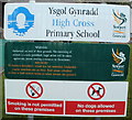
Nameboard, High Cross Primary School, Newport
The board shows that smoking and dogs are not permitted/allowed on the premises.
Image: © Jaggery
Taken: 8 Aug 2011
0.05 miles
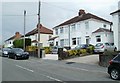
6
High Cross Drive, Newport
Houses on the south side of the road, viewed across High Cross Lane.
Image: © Jaggery
Taken: 21 Jul 2011
0.05 miles
7
High Cross Lane houses, Newport
Houses on the east side of the road, just south of the Church Close turning.
Image: © Jaggery
Taken: 21 Jul 2011
0.09 miles
8
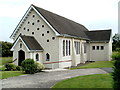
St Anne's church, High Cross, Newport
Located in Church Close. The church was built during 1958 and was dedicated on December 11th 1958. The church is one of three in the Rectorial Benefice of Bassaleg, Diocese of Monmouth in the Church in Wales, part of the worldwide Anglican Church.
Not to be confused with another St Anne's in the city of Newport, a Roman Catholic church http://www.geograph.org.uk/photo/994146 in Malpas.
Image: © Jaggery
Taken: 21 Jul 2011
0.09 miles
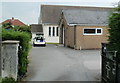
9
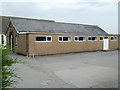
St Anne's church hall, High Cross, Newport
Viewed from Church Close. St Anne's church http://www.geograph.org.uk/photo/2535018 is behind the hall.
Image: © Jaggery
Taken: 21 Jul 2011
0.09 miles
10
Entrance to St Anne's church and church hall, High Cross, Newport
Viewed from Church Close. In the foreground is the church hall http://www.geograph.org.uk/photo/2535020 and behind it, St Anne's Church in Wales church. http://www.geograph.org.uk/photo/2535018
Not to be confused with St Anne's Roman Catholic church http://www.geograph.org.uk/photo/994146 elsewhere in the city.
Image: © Jaggery
Taken: 21 Jul 2011
0.09 miles