IMAGES TAKEN NEAR TO
Reservoir Close, NEWPORT, NP10 9BE
Introduction
This page details the photographs taken nearby to Reservoir Close, NP10 9BE by members of the Geograph project.
The Geograph project started in 2005 with the aim of publishing, organising and preserving representative images for every square kilometre of Great Britain, Ireland and the Isle of Man.

There are currently over 7.5m images from over14,400 individuals and you can help contribute to the project by visiting https://www.geograph.org.uk
Image Map
Images are licensed for reuse under creativecommons.org/licenses/by-sa/2.0
Notes
- Clicking on the map will re-center to the selected point.
- The higher the marker number, the further away the image location is from the centre of the postcode.
Image Listing (43 Images Found)
Images are licensed for reuse under creativecommons.org/licenses/by-sa/2.0
Image
Details
Distance
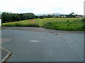
1
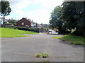
Looking towards Tudor Crescent, Newport
View from a small paved area in the corner of a field near the edge of Cefn Wood, Rogerstone.
Image: © Jaggery
Taken: 8 Aug 2011
0.02 miles
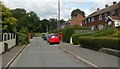
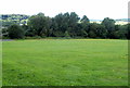
2
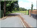
NW end of Tudor Crescent, Newport
Tudor Crescent ends at the edge of a field bordering Cefn Wood, Rogerstone. A gap in the railings on the right gives walkers access to the field.
Image: © Jaggery
Taken: 8 Aug 2011
0.02 miles
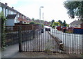
3
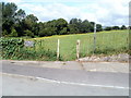
NW end of Tydu View, Newport
Beyond the turning area is an entrance into a recreation field adjacent to Cefn Wood, Rogerstone. The white-on-black notice on the railings shows
NO PARKING
DAY/NIGHT
KEEP CLEAR.
Image: © Jaggery
Taken: 8 Aug 2011
0.02 miles
4
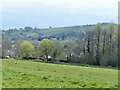
View from a recreational area, High Cross, Newport
Looking to the south-west towards Bassaleg.
The wooded area is part of Cefn Wood.
The River Ebbw runs through the valley.
Image: © Robin Drayton
Taken: 13 Apr 2022
0.05 miles
5
NW end of Tudor Crescent, Newport
This straight section connects with the main course of Tudor Crescent a few metres behind the camera.
Image: © Jaggery
Taken: 8 Aug 2011
0.06 miles
6
NW end of Tudor Crescent, Newport
Viewed through the railings at the edge of a field adjacent to Cefn Wood, Rogerstone.
Image: © Jaggery
Taken: 8 Aug 2011
0.06 miles
7
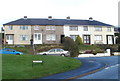
Tudor Crescent, High Cross, Newport
Tudor Crescent houses viewed from near the corner of Hillside Crescent.
Image: © Jaggery
Taken: 18 Nov 2010
0.06 miles
8
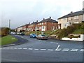
Ty-du View, High Cross, Newport
Viewed from the corner of Tudor Crescent. Ty-du is the Welsh name of the adjacent area known in English as Rogerstone.
Image: © Jaggery
Taken: 18 Nov 2010
0.06 miles
9
NW end of High Cross Drive, Newport
High Cross Drive ends at an entrance to a recreation area. The trees on the left are part of Cefn Wood, Rogerstone. The white-on-red notice on the fence shows
NO PARKING
TURNING POINT ONLY.
Image: © Jaggery
Taken: 8 Aug 2011
0.07 miles
10
SE edge of Cefn Wood, Rogerstone
Viewed from near the edge of the turning area http://www.geograph.org.uk/photo/2829418 at the NW end of High Cross Drive.
Image: © Jaggery
Taken: 8 Aug 2011
0.08 miles