IMAGES TAKEN NEAR TO
Marigold Close, NEWPORT, NP10 9AZ
Introduction
This page details the photographs taken nearby to Marigold Close, NP10 9AZ by members of the Geograph project.
The Geograph project started in 2005 with the aim of publishing, organising and preserving representative images for every square kilometre of Great Britain, Ireland and the Isle of Man.

There are currently over 7.5m images from over14,400 individuals and you can help contribute to the project by visiting https://www.geograph.org.uk
Image Map
Images are licensed for reuse under creativecommons.org/licenses/by-sa/2.0
Notes
- Clicking on the map will re-center to the selected point.
- The higher the marker number, the further away the image location is from the centre of the postcode.
Image Listing (30 Images Found)
Images are licensed for reuse under creativecommons.org/licenses/by-sa/2.0
Image
Details
Distance
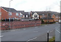
1
Primrose Way, Rogerstone
Viewed from Rivermead Way. The houses were built in 1995.
Image: © Jaggery
Taken: 26 Feb 2010
0.05 miles
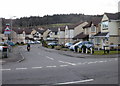
2
Corner of Rivermead Way and Afon Mead, Rogerstone
Afon Mead is Welsh/English for River Mead. Did the street naming department run out of ideas?
The river in question is the Ebbw.
Image: © Jaggery
Taken: 26 Feb 2010
0.06 miles

4
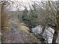
Riverside path, Rogerstone
The path heads south from Rivermead Way along the east bank of the Ebbw River.
Image: © Jaggery
Taken: 26 Feb 2010
0.11 miles
5
Camellia Avenue, Rogerstone
Camellia Avenue heads away from the Rivermead Way roundabout.
Image: © Jaggery
Taken: 26 Feb 2010
0.11 miles
6
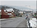
Rivermead Way, Rogerstone
Mynydd Machen in the distance.
Image: © Robin Drayton
Taken: 5 Feb 2009
0.11 miles
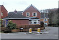
7
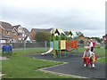
Children's play area, Rogerstone
The large housing development in this area is on the site of the former Rogerstone power station.
Image: © Robin Drayton
Taken: 31 Aug 2007
0.12 miles
8
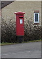
George VI postbox, Rivermead Way, Rogerstone
The postbox is located alongside a temporary narrowing of the roadway. http://www.geograph.org.uk/photo/1726724
Image: © Jaggery
Taken: 26 Feb 2010
0.13 miles
9
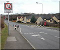
Traffic calming on Rivermead Way, Rogerstone
The view along Rivermead Way as it descends from the roundabout adjacent to Morrisons supermarket. On the right is a George VI postbox. http://www.geograph.org.uk/photo/1726729
Image: © Jaggery
Taken: 26 Feb 2010
0.13 miles
10
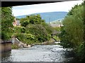
River Ebbw, view upstream
Taken from under the A467 Risca bypass. The footbridge which is just visible is the viewpoint for Image
Image: © Robin Drayton
Taken: 6 Aug 2007
0.13 miles