IMAGES TAKEN NEAR TO
Deer Park Lane, NEWPORT, NP10 8ZU
Introduction
This page details the photographs taken nearby to Deer Park Lane, NP10 8ZU by members of the Geograph project.
The Geograph project started in 2005 with the aim of publishing, organising and preserving representative images for every square kilometre of Great Britain, Ireland and the Isle of Man.

There are currently over 7.5m images from over14,400 individuals and you can help contribute to the project by visiting https://www.geograph.org.uk
Image Map
Images are licensed for reuse under creativecommons.org/licenses/by-sa/2.0
Notes
- Clicking on the map will re-center to the selected point.
- The higher the marker number, the further away the image location is from the centre of the postcode.
Image Listing (106 Images Found)
Images are licensed for reuse under creativecommons.org/licenses/by-sa/2.0
Image
Details
Distance
1
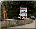
Our new collection of 3 & 4 bedroom homes, Carnegie Court, Bassaleg
The Redrow board is on the right here https://www.geograph.org.uk/photo/6099933 in March 2019.
Image: © Jaggery
Taken: 19 Mar 2019
0.07 miles
2
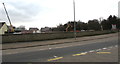
Carnegie Court house construction site, Bassaleg
Viewed across Park View in March 2019. The site is on the north bank of the Ebbw River.
The Redrow board https://www.geograph.org.uk/photo/6099936 on the right shows Our new collection of 3 & 4 bedroom homes.
Image: © Jaggery
Taken: 19 Mar 2019
0.08 miles
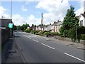
3
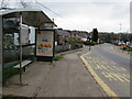
Park View bus stop and shelter, Bassaleg
This stop near the corner of Park View Gardens is for buses to Newport.
Image: © Jaggery
Taken: 19 Mar 2019
0.08 miles
4
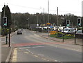
Park View pelican crossing, Bassaleg
Chambers Dictionary states that pelican in this context is adapted from "pedestrian light controlled crossing".
Image: © Jaggery
Taken: 19 Mar 2019
0.08 miles
6

Costa Coffee advert, Park View, Bassaleg
A house reflection is on the Costa advert on a Park View bus shelter in March 2019.
Image: © Jaggery
Taken: 19 Mar 2019
0.09 miles
7
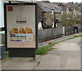
McDonald's advert on a Park View bus shelter, Bassaleg
On display here https://www.geograph.org.uk/photo/6099917 on March 19th 2019.
Image: © Jaggery
Taken: 19 Mar 2019
0.09 miles
8
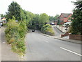
Pye Corner, Bassaleg
The area is known as Pye Corner, and so is the road, a short stretch connecting the junction with Western Valley Road http://www.geograph.org.uk/photo/1868332 behind the camera with Bassaleg Road and Park View ahead.
Image: © Jaggery
Taken: 19 Sep 2009
0.09 miles
9
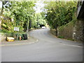
Pye Corner junction, Bassaleg
In an area of Newport known as Pye Corner, a road from the left, also named Pye Corner, meets Bassaleg Road (ahead) and Park View (under the bridge).
Image: © Jaggery
Taken: 19 Sep 2009
0.09 miles
10
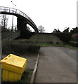
Yellow salt/grit box, Park View, Bassaleg
Located here https://www.geograph.org.uk/photo/6099914 near a footbridge over the A467.
Image: © Jaggery
Taken: 19 Mar 2019
0.10 miles