IMAGES TAKEN NEAR TO
Laurel Road, NEWPORT, NP10 8XS
Introduction
This page details the photographs taken nearby to Laurel Road, NP10 8XS by members of the Geograph project.
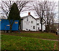
The Geograph project started in 2005 with the aim of publishing, organising and preserving representative images for every square kilometre of Great Britain, Ireland and the Isle of Man.

There are currently over 7.5m images from over14,400 individuals and you can help contribute to the project by visiting https://www.geograph.org.uk
Image Map
Images are licensed for reuse under creativecommons.org/licenses/by-sa/2.0
Notes
- Clicking on the map will re-center to the selected point.
- The higher the marker number, the further away the image location is from the centre of the postcode.
Image Listing (56 Images Found)
Images are licensed for reuse under creativecommons.org/licenses/by-sa/2.0
Image
Details
Distance
1
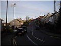
Laurel Rd, Garth
Western end, looking east.
Image: © John Lord
Taken: 12 Jan 2012
0.01 miles
2
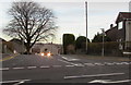
Junction of Caerphilly Road and Laurel Road, Rhiwderin
The car headlights are in Laurel Road. Viewed across the A468 Caerphilly Road.
Image: © Jaggery
Taken: 8 Jan 2019
0.04 miles
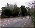
3
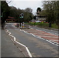
Twin pelican crossings, Caerphilly Road, Rhiwderin
Two separately-controlled parallel pedestrian crossings on the A468 Caerphilly Road.
Chambers Dictionary states that pelican in this context is adapted from "pedestrian light controlled crossing".
Image: © Jaggery
Taken: 20 Mar 2019
0.04 miles
4
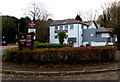
Friendly Fox in Bassaleg
Pub with dining at 33 Caerphilly Road. https://www.geograph.org.uk/photo/6019690 to closer view of the nameboard.
Image: © Jaggery
Taken: 8 Jan 2019
0.05 miles
5
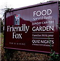
Friendly Fox nameboard, Bassaleg
Located here. https://www.geograph.org.uk/photo/6019687
Image: © Jaggery
Taken: 8 Jan 2019
0.05 miles
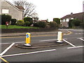
6
Pelican crossing, Caerphilly Road, Bassaleg
Across the A468 Caerphilly Road. Chambers Dictionary states that pelican
in this context is adapted from pedestrian light controlled crossing.
Image: © Jaggery
Taken: 8 Jan 2019
0.05 miles
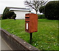
7
Queen Elizabeth II postbox, Caerphilly Road, Rhiwderin
Near a pedestrian refuge between Keep Left signs. Laurel Road is on the right.
Image: © Jaggery
Taken: 8 Jan 2019
0.05 miles
8
Queen Elizabeth II postbox in need of a repaint, Caerphilly Road, Rhiwderin
Located here https://www.geograph.org.uk/photo/6019603 viewed in March 2019.
Image: © Jaggery
Taken: 20 Mar 2019
0.05 miles
9
Southeast side of the Friendly Fox, Bassaleg
https://www.geograph.org.uk/photo/6019687 to another view of the Friendly Fox.
Image: © Jaggery
Taken: 8 Jan 2019
0.05 miles
10
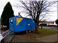
Nationwide Liberty Guard mobile unit, Bassaleg
Stand-alone health & welfare unit located here https://www.geograph.org.uk/photo/6019734 in early January 2019.
Image: © Jaggery
Taken: 8 Jan 2019
0.06 miles