IMAGES TAKEN NEAR TO
Woodside, NEWPORT, NP10 8XB
Introduction
This page details the photographs taken nearby to Woodside, NP10 8XB by members of the Geograph project.
The Geograph project started in 2005 with the aim of publishing, organising and preserving representative images for every square kilometre of Great Britain, Ireland and the Isle of Man.

There are currently over 7.5m images from over14,400 individuals and you can help contribute to the project by visiting https://www.geograph.org.uk
Image Map
Images are licensed for reuse under creativecommons.org/licenses/by-sa/2.0
Notes
- Clicking on the map will re-center to the selected point.
- The higher the marker number, the further away the image location is from the centre of the postcode.
Image Listing (236 Images Found)
Images are licensed for reuse under creativecommons.org/licenses/by-sa/2.0
Image
Details
Distance
1
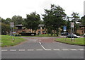
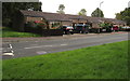
Woodside, Duffryn, Newport
Housing on the east side of Duffryn Drive.
Image: © Jaggery
Taken: 10 Aug 2016
0.04 miles
2
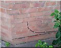
Ordnance Survey Cut Mark
This OS cut mark can be found on No86 Woodside. It marks a point 8.480m above mean sea level.
Image: © Adrian Dust
Taken: 2 Aug 2021
0.05 miles
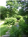
3
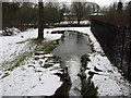
Spillway from Tredegar House Lake
The lake at Tredegar House is artificial. It is fed from the Ebbw River and water oveflowing from the lake goes down this fall and returns to the Ebbw
Image: © John Thorn
Taken: 10 Feb 2007
0.05 miles
4
Drainage channel enters an underground conduit, Duffryn Drive, Newport
The channel is part of a system http://www.geograph.org.uk/photo/2449992 feeding Tredegar House from the Ebbw River, and returning excess water to the river.
Image: © Jaggery
Taken: 8 Jun 2011
0.06 miles
5
Kingfisher Place, Duffryn, Newport
Separately-named part of Kestrel Way.
Image: © Jaggery
Taken: 10 Aug 2016
0.06 miles
6
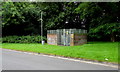
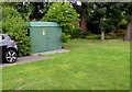
Kestrel Way electricity substation, Duffryn, Newport
The Western Power Distribution electricity substation identifier is
DUFFRYN LINKED FLATS S/S No. 536859.
Image: © Jaggery
Taken: 10 Aug 2016
0.06 miles
7
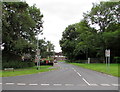
Kestrel Way, Duffryn, Newport
The 30mph speed limit on Duffryn Drive drops to 20mph on Kestrel Way.
Image: © Jaggery
Taken: 10 Aug 2016
0.06 miles
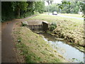
8
Stream at the foot of the lake, Tredegar Park
Image: © David Smith
Taken: 4 Jun 2018
0.07 miles
9
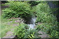
Spillway from lake in Tredegar House Country Park
Overflow channel from the southern end of the lake in this National Trust property. There is a clump of Japanese knotweed on the right bank and much more vegetation than in winter five years ago Image
Image: © M J Roscoe
Taken: 29 Jul 2017
0.07 miles
10
Jamaica Road electricity substation, Duffryn, Newport
The Western Power Distribution electricity substation is located at the northern edge of 21st century housing on the west side of Duffryn Drive. Its identifier is JAMAICA ROAD S/S No. 53-6964.
Image: © Jaggery
Taken: 10 Aug 2016
0.07 miles