IMAGES TAKEN NEAR TO
Partridge Way, NEWPORT, NP10 8WN
Introduction
This page details the photographs taken nearby to Partridge Way, NP10 8WN by members of the Geograph project.
The Geograph project started in 2005 with the aim of publishing, organising and preserving representative images for every square kilometre of Great Britain, Ireland and the Isle of Man.

There are currently over 7.5m images from over14,400 individuals and you can help contribute to the project by visiting https://www.geograph.org.uk
Image Map
Images are licensed for reuse under creativecommons.org/licenses/by-sa/2.0
Notes
- Clicking on the map will re-center to the selected point.
- The higher the marker number, the further away the image location is from the centre of the postcode.
Image Listing (84 Images Found)
Images are licensed for reuse under creativecommons.org/licenses/by-sa/2.0
Image
Details
Distance
1
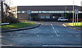
Partridge Way, Duffryn, Newport
Viewed across the B4239 Lighthouse Road.
Image: © Jaggery
Taken: 25 Dec 2013
0.03 miles
2
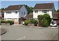
Pine Grove, Newport
Houses in the central section of Pine Grove, viewed from Lighthouse Road.
Image: © Jaggery
Taken: 20 Jun 2010
0.04 miles
3
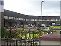
Duffryn Estate, Newport
Zig zag terraced housing. See this http://getamap.ordnancesurvey.co.uk/getamap/frames.htm?mapAction=gaz&gazName=g&gazString=ST295855 for the layout.
Image: © Robin Drayton
Taken: 9 Nov 2007
0.04 miles
4
Electricity substation alongside Lighthouse Road, Newport
The West Power Distribution substation is at the Sandy Lane junction.
Image: © Jaggery
Taken: 25 Dec 2013
0.08 miles
5
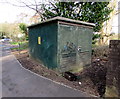
Lighthouse Road electricity substation, Newport
The dark green cabinet alongside Lighthouse Road near the corner of Sandy Lane is a Western Power Distribution electricity substation. Its identifier is LIGHTHOUSE RD S/S 536313
Image: © Jaggery
Taken: 12 Feb 2020
0.08 miles
6
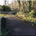
Path from Lighthouse Road to Swallow Way, Duffryn, Newport
A shortcut, and safer than walking along the edge of Lighthouse Road and Duffryn Drive to reach Swallow Way.
Image: © Jaggery
Taken: 25 Dec 2013
0.09 miles
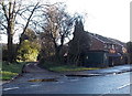
7
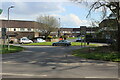
Swallow Way off Duffryn Drive
One of severla cul-de-sacs on Swallow Way. The houses form a continuous sinuous long terrace, broken only by a few footpaths, enclosing three sides of a green space behind the houses in the picture. Each porch has two entrances - one for each of the two adjoining houses.
Image: © M J Roscoe
Taken: 10 Apr 2021
0.09 miles
8
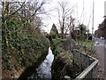
Tredegar Reen below Lighthouse Road, Newport
Reen is the local word for drainage channel.
Image: © Jaggery
Taken: 12 Feb 2020
0.09 miles
9
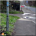
National Cycle Network Route 4 sign, Lighthouse Road, Newport
The small sign on a lamppost marks the route of National Cycle Network Route 4 which extends for 431 miles (694 km) from Greenwich (London) to Fishguard on the Pembrokeshire coast in West Wales.
Image: © Jaggery
Taken: 12 Feb 2020
0.09 miles
10
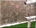
Ordnance Survey Cut Mark
This OS cut mark can be found on No83 Swallow Way. It marks a point 8.860m above mean sea level.
Image: © Adrian Dust
Taken: 2 Aug 2021
0.09 miles