IMAGES TAKEN NEAR TO
Coedkernew, NEWPORT, NP10 8TH
Introduction
This page details the photographs taken nearby to NP10 8TH by members of the Geograph project.
The Geograph project started in 2005 with the aim of publishing, organising and preserving representative images for every square kilometre of Great Britain, Ireland and the Isle of Man.

There are currently over 7.5m images from over14,400 individuals and you can help contribute to the project by visiting https://www.geograph.org.uk
Image Map
Images are licensed for reuse under creativecommons.org/licenses/by-sa/2.0
Notes
- Clicking on the map will re-center to the selected point.
- The higher the marker number, the further away the image location is from the centre of the postcode.
Image Listing (330 Images Found)
Images are licensed for reuse under creativecommons.org/licenses/by-sa/2.0
Image
Details
Distance
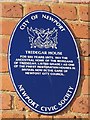
1
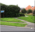
Path to Tredegar House and Country Park, Newport
From the west side of Duffryn Drive.
Image: © Jaggery
Taken: 10 Aug 2016
0.01 miles
2
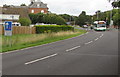
Traffic calming ahead, Duffryn Drive, Newport
The bus is on a zebra crossing at the point where Duffryn Drive is narrowed to one lane.
The sign on the left shows that vehicles on this side have priority over oncoming traffic.
Image: © Jaggery
Taken: 10 Aug 2016
0.02 miles
3
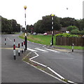
Zebra crossing, Duffryn Drive, Newport
As a traffic calming measure, Duffryn Drive is narrowed to one lane for the zebra crossing.
Image: © Jaggery
Taken: 10 Aug 2016
0.02 miles
4
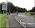
Give way to oncoming vehicles, Duffryn Drive, Newport
Oncoming vehicles have priority past the zebra crossing http://www.geograph.org.uk/photo/5069986 on the one lane width part of the road.
Image: © Jaggery
Taken: 10 Aug 2016
0.03 miles
5
Duffryn Drive bus stop and shelter, Duffryn, Newport
Opposite Nightingale Court. http://www.geograph.org.uk/photo/5069965
Image: © Jaggery
Taken: 10 Aug 2016
0.03 miles
6
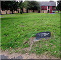
Duffryn Community 30 Years Celebration 1978-2008 plaque, Newport
The plaque is alongside a path between Duffryn Drive and Aneurin Bevan Court in the background.
Image: © Jaggery
Taken: 10 Aug 2016
0.04 miles
7
Pencarn Village, Newport
Pencarn Village, the name shown on a Bellway Homes Ltd sign viewed across Duffryn Drive, doesn't yet appear on maps. This recent development of 3-, 4- and 5-bedroom houses, and 1- and 2-bedroom apartments has Caribbean-themed street names, such as Jamaica Drive and Barbados Court.
Image: © Jaggery
Taken: 8 Jun 2011
0.05 miles
8
Jamaica Grove, Duffryn, Newport
From the corner of Duffryn Drive.
Image: © Jaggery
Taken: 10 Aug 2016
0.05 miles
10
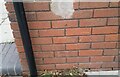
Ordnance Survey Cut Mark
This OS cut mark can be found on The Duffryn Arms. It marks a point 9.140m above mean sea level.
Image: © Adrian Dust
Taken: 2 Aug 2021
0.05 miles