IMAGES TAKEN NEAR TO
Goodrich Grove, NEWPORT, NP10 8SY
Introduction
This page details the photographs taken nearby to Goodrich Grove, NP10 8SY by members of the Geograph project.
The Geograph project started in 2005 with the aim of publishing, organising and preserving representative images for every square kilometre of Great Britain, Ireland and the Isle of Man.

There are currently over 7.5m images from over14,400 individuals and you can help contribute to the project by visiting https://www.geograph.org.uk
Image Map
Images are licensed for reuse under creativecommons.org/licenses/by-sa/2.0
Notes
- Clicking on the map will re-center to the selected point.
- The higher the marker number, the further away the image location is from the centre of the postcode.
Image Listing (60 Images Found)
Images are licensed for reuse under creativecommons.org/licenses/by-sa/2.0
Image
Details
Distance
1
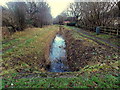
Blackwall Reen, Newport
Viewed from Morgraig Avenue. http://www.geograph.org.uk/photo/3428826 Blackwall Reen is part of a network of drainage channels, locally known as reens, in this low-lying flat area located at the NE edge of the Wentlooge Level.
Image: © Jaggery
Taken: 21 Dec 2012
0.04 miles
3
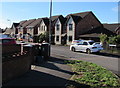
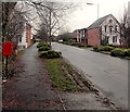
White Avenue houses, Newport
Houses on the south side of White Avenue viewed from the corner of Morgraig Avenue.
Image: © Jaggery
Taken: 13 Aug 2018
0.05 miles
4
Cycle route signs, Morgraig Avenue, Newport
A small label on the sign pole on the left shows that this route is part of National Cycle Network Route 88, a mainly coastal route from Newport to Margam Country Park via Cardiff and Bridgend. In August 2018, only short sections of the route are open.
Image: © Jaggery
Taken: 13 Aug 2018
0.07 miles
5
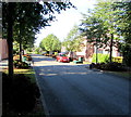
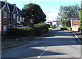
Tree-lined Morgraig Avenue, Newport
Looking south along Morgraig Avenue towards this https://www.geograph.org.uk/photo/5872482 roundabout.
Image: © Jaggery
Taken: 13 Aug 2018
0.07 miles
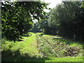
6
Morgraig Avenue, Newport
Viewed from the edge of Blackwell Reen. http://www.geograph.org.uk/photo/3428819
Image: © Jaggery
Taken: 21 Dec 2012
0.07 miles
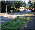
7
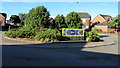
Keep Left sign on the Morgraig Avenue roundabout, Newport
The roundabout is in the middle of the Morgraig Avenue/White Avenue/Grosmont Way crossroads.
Image: © Jaggery
Taken: 13 Aug 2018
0.07 miles
8
Eastern end of Grosmont Way, Newport
Viewed from near the roundabout at the Morgraig Avenue and White Avenue junctions.
Image: © Jaggery
Taken: 21 Dec 2012
0.10 miles
9
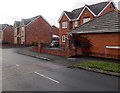
Corner of Morgraig Avenue and Picton Walk, Newport
Morgraig Avenue is one of the main roads through an area of modern housing at the southern edge of Newport. Picton Walk on the right is a small cul-de-sac.
Image: © Jaggery
Taken: 21 Dec 2012
0.10 miles
10
South along Morgraig Avenue, Newport
Viewed from the roundabout at the Morgraig Avenue/White Avenue/Grosmont Way crossroads.
Image: © Jaggery
Taken: 13 Aug 2018
0.10 miles