IMAGES TAKEN NEAR TO
Lighthouse Park, NEWPORT, NP10 8SL
Introduction
This page details the photographs taken nearby to Lighthouse Park, NP10 8SL by members of the Geograph project.
The Geograph project started in 2005 with the aim of publishing, organising and preserving representative images for every square kilometre of Great Britain, Ireland and the Isle of Man.

There are currently over 7.5m images from over14,400 individuals and you can help contribute to the project by visiting https://www.geograph.org.uk
Image Map
Images are licensed for reuse under creativecommons.org/licenses/by-sa/2.0
Notes
- Clicking on the map will re-center to the selected point.
- The higher the marker number, the further away the image location is from the centre of the postcode.
Image Listing (62 Images Found)
Images are licensed for reuse under creativecommons.org/licenses/by-sa/2.0
Image
Details
Distance
1
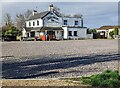
Lighthouse Inn, St Brides Wentlooge
Accessed from the B4239 via Beach Road.
Image: © Jaggery
Taken: 19 Mar 2023
0.09 miles
2
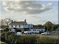
The Lighthouse
Public House on the Gwent Levels.
Image: © Alan Hughes
Taken: 17 Nov 2021
0.09 miles
3
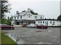
The Lighthouse Inn
Situated beside the Coastal Path near Wentlooge
Image: © Eirian Evans
Taken: 24 Jul 2015
0.10 miles
4
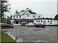
The Lighthouse Inn, St Brides
Good place for refreshment on the Wales Coast Path between Newport and Cardiff
Image: © Eirian Evans
Taken: 24 Jul 2015
0.10 miles
5
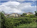
Lighthouse Park
Residential park on the South Wales coast
Image: © Eirian Evans
Taken: 24 May 2021
0.10 miles
6
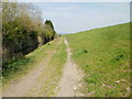
Coastal path heading northeast from Lighthouse Park
The path is between Wharf Reen (drainage channel) on the left, and the sea wall and the Severn Estuary on the right.
Image: © Jaggery
Taken: 22 Apr 2010
0.10 miles
7
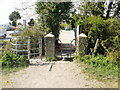
Kissing gate and stile, Lighthouse Park
Access between Lighthouse Park, and the sea wall and coastal path, across Wharf Reen (drainage channel), is by either stile or kissing gate.
Image: © Jaggery
Taken: 22 Apr 2010
0.10 miles
8
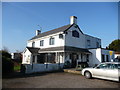
The Lighthouse Inn at St. Brides Wentloog
A longstanding and popular inn situated below the sea wall and a lovely spot to visit, enjoy a stroll and a pint or Sunday lunch.
Image: © Jeremy Bolwell
Taken: 17 Feb 2013
0.10 miles
9
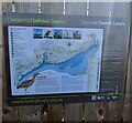
Discover Gwent Levels information board, St Brides Wentlooge
On a fence at the edge of Lighthouse Park Sea Wall Car Park.
The bilingual board shows that "Discover Gwent Levels" is
"Darganfod Lefelau Gwent" in Welsh.
The board is located near the sea wall which extends for 35km
along the coast. Without the wall, the Gwent Levels in its present
form could not exist. Romans began draining the wild coastal marshes
around 2,000 years ago to create grazing land. In the early Middle Ages
the monks of Goldcliff Priory rebuilt and extended the Roman sea defences.
In the following centuries, as the sea struggled to reclaim the borrowed
land, the sea wall was abandoned, rebuilt, modified and moved inland
many times. Without the sea wall, much of the Gwent Levels would be
inundated by every high tide.
Image: © Jaggery
Taken: 19 Mar 2023
0.11 miles
10
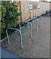
Chain your bicycle here, St Brides Wentlooge
At the edge of Lighthouse Park Sea Wall Car Park, near the Lighthouse Inn. https://www.geograph.org.uk/photo/7435289
Image: © Jaggery
Taken: 19 Mar 2023
0.11 miles