IMAGES TAKEN NEAR TO
Manor Park, NEWPORT, NP10 8SA
Introduction
This page details the photographs taken nearby to Manor Park, NP10 8SA by members of the Geograph project.
The Geograph project started in 2005 with the aim of publishing, organising and preserving representative images for every square kilometre of Great Britain, Ireland and the Isle of Man.

There are currently over 7.5m images from over14,400 individuals and you can help contribute to the project by visiting https://www.geograph.org.uk
Image Map
Images are licensed for reuse under creativecommons.org/licenses/by-sa/2.0
Notes
- Clicking on the map will re-center to the selected point.
- The higher the marker number, the further away the image location is from the centre of the postcode.
Image Listing (107 Images Found)
Images are licensed for reuse under creativecommons.org/licenses/by-sa/2.0
Image
Details
Distance
1
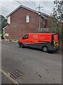
Dyno plumbing van, Manor Park, Newport
Text on the van in August 2021 includes "24 Hour Emergency Plumbing Service". Dyno is a drainage and plumbing company founded in 1963 as Dyno-Rod.
Image: © Jaggery
Taken: 14 Aug 2021
0.01 miles
2
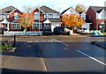
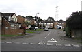
Change of house type in Manor Park, Newport
Opposite a T-junction in Manor Park, there are different types of houses on the left and on the right. Manor Park is an area of about 130 houses built at the start of the 21st century on the south side of Morgan Way.
Image: © Jaggery
Taken: 10 Nov 2012
0.02 miles
3
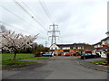
Spring blossom, power lines and pylons, Manor Park, Newport
A late April view of the SE corner of Manor Park, an area of about 130 houses built
at the start of the 21st century on the south side of Morgan Way.
Image: © Jaggery
Taken: 25 Apr 2013
0.03 miles
4
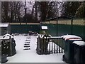
Snow in March 2023, Manor Park. Newport
A suburban rear garden at about 7 metres (c 23ft) above sea level on March 8th 2023.
Image: © Peter G M Grayson
Taken: 8 Mar 2023
0.04 miles
5
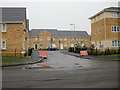
Manor Park, Duffryn, Newport
The northern end of Manor Park, viewed across Morgan Way.
Image: © Jaggery
Taken: 10 Aug 2016
0.05 miles
6
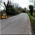
Temporary 10mph speed limit, Lighthouse Road, Newport
This late April 2013 view shows a temporary yellow sign for a 10mph speed limit on the approach to temporary traffic lights near ongoing engineering work on and near Pheasants Bridge over the South Wales main railway line.
Image: © Jaggery
Taken: 25 Apr 2013
0.06 miles
7
Schooner Avenue, Newport
Viewed from the eastern end of Morgan Way, near the junction with Lighthouse Road.
The houses were built c2007.
Image: © Jaggery
Taken: 21 Jan 2010
0.06 miles
8
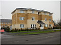
Chargres House, Newport
Apartment building on the corner of Schooner Avenue and Morgan Way.
A similar building, Providence House,http://www.geograph.org.uk/photo/1923312 is nearby.
Image: © Jaggery
Taken: 21 Jan 2010
0.06 miles
9
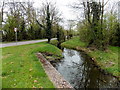
Pontygwcw Reen, Newport
Viewed from the corner of Morgan Way looking towards Lighthouse Road. Pontygwcw Reen is one
of many drainage channels, locally known as reens, in this low-lying flat area at the NE edge of the Wentlooge Level.
Image: © Jaggery
Taken: 25 Apr 2013
0.06 miles
10
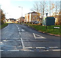
Eastern end of Morgan Way, Newport
Viewed from Lighthouse Road.
Image: © Jaggery
Taken: 10 Nov 2012
0.06 miles