IMAGES TAKEN NEAR TO
Rhiwderin, NEWPORT, NP10 8RR
Introduction
This page details the photographs taken nearby to NP10 8RR by members of the Geograph project.
The Geograph project started in 2005 with the aim of publishing, organising and preserving representative images for every square kilometre of Great Britain, Ireland and the Isle of Man.

There are currently over 7.5m images from over14,400 individuals and you can help contribute to the project by visiting https://www.geograph.org.uk
Image Map
Images are licensed for reuse under creativecommons.org/licenses/by-sa/2.0
Notes
- Clicking on the map will re-center to the selected point.
- The higher the marker number, the further away the image location is from the centre of the postcode.
Image Listing (2 Images Found)
Images are licensed for reuse under creativecommons.org/licenses/by-sa/2.0
Image
Details
Distance
1
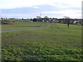
Croes-Carn-Einion farm
Location of the 'Farmer's daughter' restaurant.
Image: © Roger Cornfoot
Taken: 1 Mar 2007
0.02 miles
2
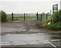
Entrance gate and road to Croescarneinion Farm
Located at the junction of Coc-y-North Lane and Pentre-poeth Road.
The farm buildings are about 400 metres away.
Image: © Jaggery
Taken: 29 May 2010
0.25 miles