IMAGES TAKEN NEAR TO
Rhiwderin, NEWPORT, NP10 8RP
Introduction
This page details the photographs taken nearby to NP10 8RP by members of the Geograph project.
The Geograph project started in 2005 with the aim of publishing, organising and preserving representative images for every square kilometre of Great Britain, Ireland and the Isle of Man.

There are currently over 7.5m images from over14,400 individuals and you can help contribute to the project by visiting https://www.geograph.org.uk
Image Map
Images are licensed for reuse under creativecommons.org/licenses/by-sa/2.0
Notes
- Clicking on the map will re-center to the selected point.
- The higher the marker number, the further away the image location is from the centre of the postcode.
Image Listing (6 Images Found)
Images are licensed for reuse under creativecommons.org/licenses/by-sa/2.0
Image
Details
Distance
1
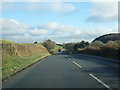
Bend in the road, Ty'n-y-ffynnon
Caerphilly Road (A468) bends past the northern edge of Ty'n-y-ffynnon Farm.
Image: © Jaggery
Taken: 1 Apr 2010
0.03 miles
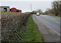
2
Ty'n-y-ffynnon farmhouse
Located on the southeast side of the other farm buildings. Viewed from Caerphilly Road, looking south.
Image: © Jaggery
Taken: 1 Apr 2010
0.04 miles
3
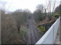
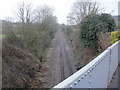
Railway line heading east from Caerphilly Road
A single line heads towards Rhiwderin away from the bridge carrying Caerphilly Road (A468). The line, formerly a passenger route, now connects Machen quarry with Park Junction, Newport. The quarry provides ballast for the western region of Network Rail. http://www.geograph.org.uk/photo/1781226 to the view in the opposite direction.
Image: © Jaggery
Taken: 1 Apr 2010
0.05 miles
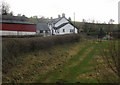
4
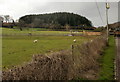
Y-Neuadd Farm
The view from Caerphilly Road across the northern edge of Y-Neuadd Farm.
Image: © Jaggery
Taken: 1 Apr 2010
0.06 miles
5
Railway line heading west from Caerphilly Road
A single railway line heads west away from the bridge carrying the A468 (Caerphilly Road). Formerly a passenger route, the line remains in use to connect Machen quarry with Park Junction, Newport. The quarry provides ballast for the western region of Network Rail.
http://www.geograph.org.uk/photo/1781238 to the view in the opposite direction.
Image: © Jaggery
Taken: 1 Apr 2010
0.14 miles