IMAGES TAKEN NEAR TO
Beaumaris Close, NEWPORT, NP10 8QW
Introduction
This page details the photographs taken nearby to Beaumaris Close, NP10 8QW by members of the Geograph project.
The Geograph project started in 2005 with the aim of publishing, organising and preserving representative images for every square kilometre of Great Britain, Ireland and the Isle of Man.

There are currently over 7.5m images from over14,400 individuals and you can help contribute to the project by visiting https://www.geograph.org.uk
Image Map
Images are licensed for reuse under creativecommons.org/licenses/by-sa/2.0
Notes
- Clicking on the map will re-center to the selected point.
- The higher the marker number, the further away the image location is from the centre of the postcode.
Image Listing (119 Images Found)
Images are licensed for reuse under creativecommons.org/licenses/by-sa/2.0
Image
Details
Distance
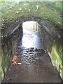
2
Entrance to foot tunnel beneath railway, Rhiwderin
Image: © John Lord
Taken: 12 Jan 2012
0.03 miles
3
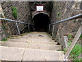
Steps descending to a railway underpass, Rhiwderin
Steep descent from the A468 Caerphilly Road.
Image: © Jaggery
Taken: 20 Mar 2019
0.03 miles
4
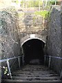
Steps to footway beneath railway, Rhiwderin
Image: © John Lord
Taken: 12 Jan 2012
0.03 miles
5
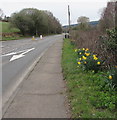
Roadside daffodils, Caerphilly Road, Rhiwderin
Viewed on March 20th 2019.
Image: © Jaggery
Taken: 20 Mar 2019
0.04 miles
6
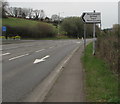
Pentrepoeth School direction sign, Caerphilly Road, Rhiwderin
Showing that Pentrepoeth School is Ysgol Pentrepoeth in Welsh, the sign points towards Caerphilly Close. https://www.geograph.org.uk/photo/6113786
Image: © Jaggery
Taken: 20 Mar 2019
0.05 miles
7
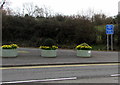
Caerphilly Road flower tubs, Rhiwderin
On March 20th 2019 daffodils are in the tubs near the corner of Caerphilly Close.
The sign on the right shows Police vehicles only and its Welsh equivalent.
Image: © Jaggery
Taken: 20 Mar 2019
0.05 miles
8
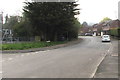
SE along Harlech Drive, Rhiwderin
Looking to the southeast along Harlech Drive towards Beaumaris Close and Caernarvon Drive.
A recreation area is on the left. https://www.geograph.org.uk/photo/6128582
Image: © Jaggery
Taken: 17 Apr 2019
0.05 miles
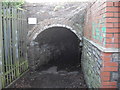
9
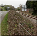
Static railway sign in Rhiwderin
Black cross on a white background viewed from Caerphilly Road.
The single track railway line used to be a passenger route.
It is now used to connect Machen quarry with Park Junction in Newport.
Image: © Jaggery
Taken: 20 Mar 2019
0.05 miles
10
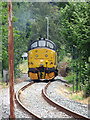
Class 37 locomotive at Rhiwderin Crossing
Colas Rail class 37 No. 37219 is seen on track data recording duties (with extra, technical equipment mounted on its ends) as its approaches Rhiwderin Crossing on its way to Machen Quarry.
Image: © Gareth James
Taken: 15 Jul 2018
0.07 miles