IMAGES TAKEN NEAR TO
St. Basils Crescent, NEWPORT, NP10 8PH
Introduction
This page details the photographs taken nearby to St. Basils Crescent, NP10 8PH by members of the Geograph project.
The Geograph project started in 2005 with the aim of publishing, organising and preserving representative images for every square kilometre of Great Britain, Ireland and the Isle of Man.

There are currently over 7.5m images from over14,400 individuals and you can help contribute to the project by visiting https://www.geograph.org.uk
Image Map
Images are licensed for reuse under creativecommons.org/licenses/by-sa/2.0
Notes
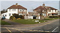
- Clicking on the map will re-center to the selected point.
- The higher the marker number, the further away the image location is from the centre of the postcode.
Image Listing (144 Images Found)
Images are licensed for reuse under creativecommons.org/licenses/by-sa/2.0
Image
Details
Distance
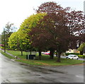
1
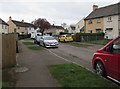
Car-lined St Basil's Crescent, Bassaleg
Viewed from the corner of Laurel Road.
Image: © Jaggery
Taken: 19 Mar 2019
0.02 miles
2
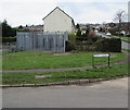
St Basil's Crescent electricity substation, Bassaleg
Western Power Distribution electricity substation on the corner of St Basil's Crescent and Laurel Road.
The substation identifier is ST BASILS CRES. BASSALEG S/S 531180
Image: © Jaggery
Taken: 19 Mar 2019
0.02 miles
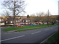
4
Laurel Road bus stop and shelter, Bassaleg
This stop is for buses to Market Square bus station in Newport.
Image: © Jaggery
Taken: 19 Mar 2019
0.03 miles
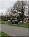
5
Bus stop and shelter under trees, Laurel Road, Bassaleg
This photo taken on April 25th 2019 contrasts with a leafless view https://www.geograph.org.uk/photo/6091187 on March 19th 2019.
Image: © Jaggery
Taken: 25 Apr 2019
0.03 miles
6
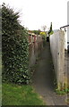
Narrow public footpath in Bassaleg
From the corner of Caerphilly Road and Laurel Drive,
the path leads to St Basil's Crescent.
Image: © Jaggery
Taken: 19 Mar 2019
0.04 miles
7
Up Laurel Road, Bassaleg
Laurel Road ascends away from the camera near the corner of St Basil's Crescent.
Image: © Jaggery
Taken: 19 Mar 2019
0.05 miles
8
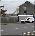
Machen Pharmacy van parked in Laurel Road, Bassaleg
The van is based at 36 Commercial Road in Machen. https://www.geograph.org.uk/photo/6087274
Image: © Jaggery
Taken: 19 Mar 2019
0.06 miles
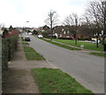
9
Corner of Laurel Drive, Bassaleg
Houses at the southern end of Laurel Drive, viewed across Caerphilly Road (A468).
Image: © Jaggery
Taken: 5 Mar 2011
0.06 miles
10
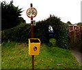
Yellow litter bin above Caerphilly Road, Bassaleg
The bin is below a public footpath direction sign pointing here. https://www.geograph.org.uk/photo/6091241
The circular sign indicates that cycling is not allowed on the footpath.
Image: © Jaggery
Taken: 19 Mar 2019
0.06 miles