IMAGES TAKEN NEAR TO
Caerphilly Road, NEWPORT, NP10 8LJ
Introduction
This page details the photographs taken nearby to Caerphilly Road, NP10 8LJ by members of the Geograph project.
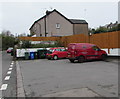
The Geograph project started in 2005 with the aim of publishing, organising and preserving representative images for every square kilometre of Great Britain, Ireland and the Isle of Man.

There are currently over 7.5m images from over14,400 individuals and you can help contribute to the project by visiting https://www.geograph.org.uk
Image Map
Images are licensed for reuse under creativecommons.org/licenses/by-sa/2.0
Notes
- Clicking on the map will re-center to the selected point.
- The higher the marker number, the further away the image location is from the centre of the postcode.
Image Listing (103 Images Found)
Images are licensed for reuse under creativecommons.org/licenses/by-sa/2.0
Image
Details
Distance
1
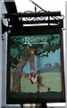
The Ruperra name sign, Bassaleg
Hanging from a wall bracket on the right here. https://www.geograph.org.uk/photo/2771212
Image: © Jaggery
Taken: 20 Mar 2019
0.01 miles
2
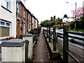
Pavement slightly below Caerphilly Road, Bassaleg
Between the Pentre-Poeth Road junction and the Garth Terrace junction.
Image: © Jaggery
Taken: 20 Mar 2019
0.01 miles
3
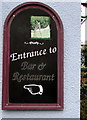
Entrance to Bar & Restaurant direction sign on the Ruperra, Bassaleg
On the wall here. https://www.geograph.org.uk/photo/6113712
Image: © Jaggery
Taken: 20 Mar 2019
0.02 miles
4
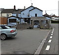
Car park on the south side of the Ruperra Arms, Bassaleg
Alongside Pentre-Poeth Road.
Image: © Jaggery
Taken: 20 Mar 2019
0.02 miles
6
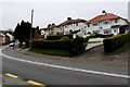
Houses above a bend in Caerphilly Road, Bassaleg
Above the north side of the A468 Caerphilly Road. The double white lines indicate no overtaking.
Image: © Jaggery
Taken: 20 Mar 2019
0.02 miles
7
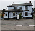
Southeast side of the Ruperra, Bassaleg
Pentre-poeth Road side of the pub on the corner of Caerphilly Road. A sign on the left points left along Pentre-poeth Road, part of National Cycle Network Route 4 from London to Fishguard via Reading, Bath, Bristol, Newport, Swansea, Llanelli and St Davids. Here in Wales, the route is one of the branches of the Celtic Trail cycle route.
Image: © Jaggery
Taken: 20 Mar 2019
0.02 miles
8
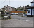
Junction of Cowshed Lane and Pentre-poeth Road, Bassaleg
Cowshed Lane from the left joins Pentre-poeth Road. The Ruperra pub https://www.geograph.org.uk/photo/6113712 is on the right.
Image: © Jaggery
Taken: 20 Mar 2019
0.02 miles
9
Wilding & Kent van, Pentre-Poeth Road, Bassaleg
Parked near the Ruperra Arms. Wilding & Kent retail & catering butchers are based in Ringland, Newport.
Image: © Jaggery
Taken: 20 Mar 2019
0.02 miles
10
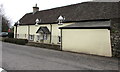
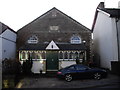
Grade II listed Fairoak, Bassaleg
Pentre-Poeth Road side of the Grade II listed 17th century house on the corner of Cowshed Lane.
Image: © Jaggery
Taken: 20 Mar 2019
0.03 miles