IMAGES TAKEN NEAR TO
Caerphilly Road, NEWPORT, NP10 8LF
Introduction
This page details the photographs taken nearby to Caerphilly Road, NP10 8LF by members of the Geograph project.
The Geograph project started in 2005 with the aim of publishing, organising and preserving representative images for every square kilometre of Great Britain, Ireland and the Isle of Man.

There are currently over 7.5m images from over14,400 individuals and you can help contribute to the project by visiting https://www.geograph.org.uk
Image Map
Images are licensed for reuse under creativecommons.org/licenses/by-sa/2.0
Notes
- Clicking on the map will re-center to the selected point.
- The higher the marker number, the further away the image location is from the centre of the postcode.
Image Listing (149 Images Found)
Images are licensed for reuse under creativecommons.org/licenses/by-sa/2.0
Image
Details
Distance
1
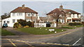
Corner of Laurel Drive, Bassaleg
Houses at the southern end of Laurel Drive, viewed across Caerphilly Road (A468).
Image: © Jaggery
Taken: 5 Mar 2011
0.02 miles
2
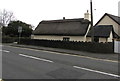
Grade II listed thatched cottage, 27 Caerphilly Road, Bassaleg
The single-storey cottage probably dates from the later 17th century,
a rare example of a thatched roof building in the city of Newport in 2019.
The building was Grade II listed in 1988.
Image: © Jaggery
Taken: 19 Mar 2019
0.02 miles
3
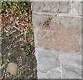
Ordnance Survey Cut Mark
This OS cut mark can be found on the wall of No50 Caerphilly Road. It marks a point 35.909m above mean sea level.
Image: © Adrian Dust
Taken: 29 Dec 2019
0.03 miles
4
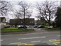
St Benedict's Court, Bassaleg
Set back from the south side of Caerphilly Road.
Image: © Jaggery
Taken: 19 Mar 2019
0.03 miles
5
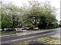
White blossom, St Benedict's Court, Bassaleg
Fallen blossom covers the pavement and part of Caerphilly Road on April 25th 2019.
Image: © Jaggery
Taken: 25 Apr 2019
0.03 miles
6
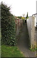
Narrow public footpath in Bassaleg
From the corner of Caerphilly Road and Laurel Drive,
the path leads to St Basil's Crescent.
Image: © Jaggery
Taken: 19 Mar 2019
0.03 miles
7
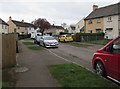
Car-lined St Basil's Crescent, Bassaleg
Viewed from the corner of Laurel Road.
Image: © Jaggery
Taken: 19 Mar 2019
0.04 miles
8
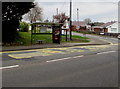
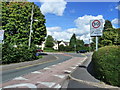
Caerphilly Road bus stop and shelter, Bassaleg
Located near the corner of Laurel Drive, this stop on the north side of the A468 Caerphilly Road is for buses to Newport. A Costa Coffee advert is on the shelter on March 19th 2019.
Image: © Jaggery
Taken: 19 Mar 2019
0.05 miles
9
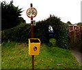
Yellow litter bin above Caerphilly Road, Bassaleg
The bin is below a public footpath direction sign pointing here. https://www.geograph.org.uk/photo/6091241
The circular sign indicates that cycling is not allowed on the footpath.
Image: © Jaggery
Taken: 19 Mar 2019
0.05 miles