IMAGES TAKEN NEAR TO
Brynhedydd, NEWPORT, NP10 8JW
Introduction
This page details the photographs taken nearby to Brynhedydd, NP10 8JW by members of the Geograph project.
The Geograph project started in 2005 with the aim of publishing, organising and preserving representative images for every square kilometre of Great Britain, Ireland and the Isle of Man.

There are currently over 7.5m images from over14,400 individuals and you can help contribute to the project by visiting https://www.geograph.org.uk
Image Map
Images are licensed for reuse under creativecommons.org/licenses/by-sa/2.0
Notes
- Clicking on the map will re-center to the selected point.
- The higher the marker number, the further away the image location is from the centre of the postcode.
Image Listing (62 Images Found)
Images are licensed for reuse under creativecommons.org/licenses/by-sa/2.0
Image
Details
Distance
1
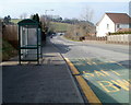
Caerphilly Road bus shelter, Rhiwderin
The bus stop, near the Laurel Road junction, http://www.geograph.org.uk/photo/2771362 is mainly used by Stagecoach buses on route 50 from Newport to Bargoed via Caerphilly.
Image: © Jaggery
Taken: 5 Mar 2011
0.08 miles
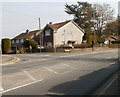
2
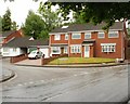
Caerphilly Close, Rhiwderin
Viewed from the Caerphilly Road (A468) end. The Friendly Fox pub is on the right. http://www.geograph.org.uk/photo/1780840
Image: © Jaggery
Taken: 5 Mar 2011
0.09 miles
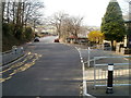
3
Caerphilly Close, Rhiwderin
From the south side of the A468 Caerphilly Road, Caerphilly Close leads to Oaklands Park Drive and Cwm Cwddy Drive.
Image: © Jaggery
Taken: 20 Mar 2019
0.10 miles
4
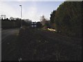
Railway alongside Caerphilly Rd, Rhiwderin
Image: © John Lord
Taken: 12 Jan 2012
0.10 miles
5
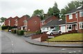
South side of Parkwood Drive, Newport
Houses on the south side of Parkwood Drive, Pentrepoeth, Bassaleg, viewed from the corner of Cwm Cwddy Drive.
Image: © Jaggery
Taken: 29 May 2010
0.11 miles
6
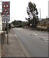
Ysgol 200 llath/School 200 yards, Caerphilly Road, Rhiwderin
Welsh/English warning sign on the approach to Pentrepoeth Primary School.
Image: © Jaggery
Taken: 20 Mar 2019
0.11 miles
7
Parkwood Drive, Newport
The western end of Parkwood Drive, Pentrepoeth, Bassaleg, viewed from Cwm Cwddy Drive.
Image: © Jaggery
Taken: 29 May 2010
0.11 miles
8
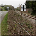
Static railway sign in Rhiwderin
Black cross on a white background viewed from Caerphilly Road.
The single track railway line used to be a passenger route.
It is now used to connect Machen quarry with Park Junction in Newport.
Image: © Jaggery
Taken: 20 Mar 2019
0.12 miles
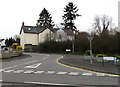
9
Corner of Laurel Road and Caerphilly Road, Rhiwderin
The houses are at the western end of Laurel Road, viewed across Caerphilly Road (A468).
Image: © Jaggery
Taken: 5 Mar 2011
0.12 miles
10
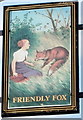
The Friendly Fox pub sign, Rhiwderin
Located in a frame at the roadside edge of the pub. http://www.geograph.org.uk/photo/1780840
Adult foxes are usually about 2 feet long, so either the one depicted here is a very large fox, or the woman is very short!
Image: © Jaggery
Taken: 5 Mar 2011
0.12 miles