IMAGES TAKEN NEAR TO
Lancers Way, NEWPORT, NP10 8HN
Introduction
This page details the photographs taken nearby to Lancers Way, NP10 8HN by members of the Geograph project.
The Geograph project started in 2005 with the aim of publishing, organising and preserving representative images for every square kilometre of Great Britain, Ireland and the Isle of Man.

There are currently over 7.5m images from over14,400 individuals and you can help contribute to the project by visiting https://www.geograph.org.uk
Image Map
Images are licensed for reuse under creativecommons.org/licenses/by-sa/2.0
Notes
- Clicking on the map will re-center to the selected point.
- The higher the marker number, the further away the image location is from the centre of the postcode.
Image Listing (62 Images Found)
Images are licensed for reuse under creativecommons.org/licenses/by-sa/2.0
Image
Details
Distance
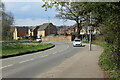
1
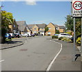
Lancers Way, Duffryn, Newport
Viewed from Lighthouse Road. There are 17 houses in Lancers Way, built c2001.
Image: © Jaggery
Taken: 20 Jun 2010
0.03 miles
2
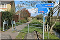
Cycle and pedestrian path by Sea Wall Reen
Wales Coast Path leaves Lighthouse Road Image heading towards the River Ebbw. The signs may not be pointing in the right direction; the way to Newport is along the path as indicated on the post.
Image: © M J Roscoe
Taken: 10 Apr 2021
0.04 miles
3
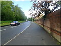
Wales Coast Path on Lighthouse Road
The path follows the road for about 400m at this point
Image: © Eirian Evans
Taken: 24 May 2021
0.04 miles
4
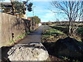
Wales Coast Path, Duffryn, Newport
This part of the Wales Coast Path is alongside a drainage channel, Sea Wall Reen.
http://www.geograph.org.uk/photo/3223360
Viewed from Lighthouse Road. A shadow on the fence is being cast by the Wales Coast Path sign.
Image: © Jaggery
Taken: 25 Dec 2013
0.04 miles
5
Embankment between Lancers Way & River Ebbw
Flood defence behind housing estate.
Image: © M J Roscoe
Taken: 10 Apr 2021
0.05 miles
6
Track along Sea Wall Reen, Newport
Viewed from Lighthouse Road opposite the Heron Way junction.
Sea Wall Reen http://www.geograph.org.uk/photo/3223360 is one of many drainage channels is this area, part of the Wentloog Level.
The houses are in Edney View.
Image: © Jaggery
Taken: 10 Nov 2012
0.06 miles
7
Sea Wall Reen, Newport
Viewed from Lighthouse Road opposite the Heron Way junction.
Sea Wall Reen is one of many drainage channels is this area, part of the Wentloog Level.
Image: © Jaggery
Taken: 10 Nov 2012
0.06 miles
8
Heron Way, Duffryn
The houses on this estate seem to be winding blocks of terraces with parking on the opposite side of the roac
Image: © Eirian Evans
Taken: 24 May 2021
0.06 miles
9
Wales Coast Path, Lighthouse Road, Duffryn
The path leaves the side of the road turning right after the tree at the corner of the brick wall.
Image: © M J Roscoe
Taken: 10 Apr 2021
0.06 miles
10
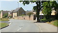
Houses on a bend in Lighthouse Road, Newport
The houses are between the turnings for Heron Way and Lancers Way.
Image: © Jaggery
Taken: 20 Jun 2010
0.07 miles