IMAGES TAKEN NEAR TO
Viscount Evan Drive, NEWPORT, NP10 8HJ
Introduction
This page details the photographs taken nearby to Viscount Evan Drive, NP10 8HJ by members of the Geograph project.
The Geograph project started in 2005 with the aim of publishing, organising and preserving representative images for every square kilometre of Great Britain, Ireland and the Isle of Man.

There are currently over 7.5m images from over14,400 individuals and you can help contribute to the project by visiting https://www.geograph.org.uk
Image Map
Images are licensed for reuse under creativecommons.org/licenses/by-sa/2.0
Notes
- Clicking on the map will re-center to the selected point.
- The higher the marker number, the further away the image location is from the centre of the postcode.
Image Listing (60 Images Found)
Images are licensed for reuse under creativecommons.org/licenses/by-sa/2.0
Image
Details
Distance
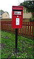
1
Viscount Evan Drive, Duffryn
Showing position of Postbox No. NP10 150.
See Image] for postbox.
Image: © JThomas
Taken: 15 Oct 2019
0.03 miles
2
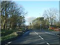
Viscount Evan Drive, Duffryn, Newport
Viewed from the edge of the B4239 Lighthouse Road.
Image: © Jaggery
Taken: 25 Dec 2013
0.04 miles
3
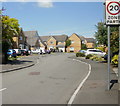
Lancers Way, Duffryn, Newport
Viewed from Lighthouse Road. There are 17 houses in Lancers Way, built c2001.
Image: © Jaggery
Taken: 20 Jun 2010
0.05 miles
4
Elizabeth II postbox on Lighthouse Road, Duffryn
Postbox No. NP10 150.
See Image] for context.
Image: © JThomas
Taken: 15 Oct 2019
0.05 miles
5
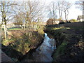
Reen on the north side of Lighthouse Road, Duffryn, Newport
Reen is the local word for a drainage channel, part of a network draining the low-lying Wentlooge Level.
Image: © Jaggery
Taken: 25 Dec 2013
0.06 miles
6
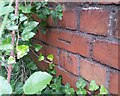
Ordnance Survey Cut Mark
This OS cut mark can be found on the wall above Pontygwen Reen on Lighthouse Road. It marks a point 7.810m above mean sea level.
Image: © Adrian Dust
Taken: 2 Aug 2021
0.07 miles
7
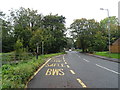
Bus stop on Lighthouse Road (B4239), Duffryn
Image: © JThomas
Taken: 15 Oct 2019
0.07 miles
8
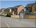
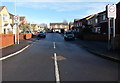
Viscount Evan Drive, Duffryn, Newport
Houses on the east side of the street, view from the corner of Lighthouse Road.
The houses were built in the first decade of the 21st century.
Image: © Jaggery
Taken: 20 Jun 2010
0.07 miles
9
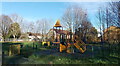
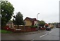
Children's play area in Duffryn, Newport
At the edge of the B4239 Lighthouse Road, opposite this http://www.geograph.org.uk/photo/3829166 junction.
Image: © Jaggery
Taken: 25 Dec 2013
0.07 miles