IMAGES TAKEN NEAR TO
Longtown Grove, NEWPORT, NP10 8HD
Introduction
This page details the photographs taken nearby to Longtown Grove, NP10 8HD by members of the Geograph project.
The Geograph project started in 2005 with the aim of publishing, organising and preserving representative images for every square kilometre of Great Britain, Ireland and the Isle of Man.

There are currently over 7.5m images from over14,400 individuals and you can help contribute to the project by visiting https://www.geograph.org.uk
Image Map
Images are licensed for reuse under creativecommons.org/licenses/by-sa/2.0
Notes
- Clicking on the map will re-center to the selected point.
- The higher the marker number, the further away the image location is from the centre of the postcode.
Image Listing (37 Images Found)
Images are licensed for reuse under creativecommons.org/licenses/by-sa/2.0
Image
Details
Distance
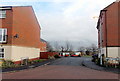
1
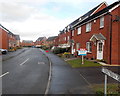
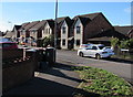
Southern end of Longtown Grove, Newport
Viewed from near the roundabout at the southern end of Longtown Grove,
looking in the direction of White Avenue.
Image: © Jaggery
Taken: 21 Dec 2012
0.01 miles
2
SE end of Morgraig Avenue, Newport
Viewed from the corner of Longtown Grove, opposite a roundabout.
Image: © Jaggery
Taken: 21 Dec 2012
0.05 miles
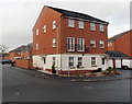
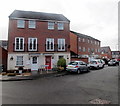
3
Corner of Morgraig Avenue and Picton Walk, Newport
Morgraig Avenue is one of the main roads through an area of modern housing at the southern edge of Newport. Picton Walk on the right is a small cul-de-sac.
Image: © Jaggery
Taken: 21 Dec 2012
0.08 miles
4
NE side of Narbeth Close, Newport
Viewed from Oystermouth Way. The street name sign shows Narbeth. Neighbouring streets are named after locations in Wales, so it seems Narbeth is an error for Narberth.
Image: © Jaggery
Taken: 21 Dec 2012
0.08 miles
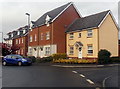
5
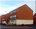
White Avenue houses, Newport
Houses on the south side of White Avenue viewed from the corner of Morgraig Avenue.
Image: © Jaggery
Taken: 13 Aug 2018
0.08 miles
6
Corner of Kidwelly Close and Oystermouth Road, Newport
Viewed across Oystermouth Road.
Image: © Jaggery
Taken: 21 Dec 2012
0.10 miles
7
SW side of Narbeth Close, Newport
Viewed from Oystermouth Way. The street name sign shows Narbeth. Neighbouring streets are named after locations in Wales, so it seems Narbeth is an error for Narberth.
Image: © Jaggery
Taken: 21 Dec 2012
0.10 miles
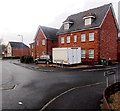
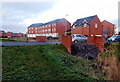
8
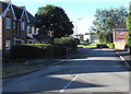
South along Morgraig Avenue, Newport
Viewed from the roundabout at the Morgraig Avenue/White Avenue/Grosmont Way crossroads.
Image: © Jaggery
Taken: 13 Aug 2018
0.11 miles
9
Kidwelly Close, Newport
A short cul-de-sac viewed from Oystermouth Way.
Image: © Jaggery
Taken: 21 Dec 2012
0.11 miles
10
Narberth Close houses, Newport
Viewed across Oystermouth Way. The houses are alongside a drainage channel
named Ffynnon-wen Reen. The car at centre-right is on a small bridge over the Reen.
Image: © Jaggery
Taken: 21 Dec 2012
0.12 miles