IMAGES TAKEN NEAR TO
Rhymney Way, NEWPORT, NP10 8GN
Introduction
This page details the photographs taken nearby to Rhymney Way, NP10 8GN by members of the Geograph project.
The Geograph project started in 2005 with the aim of publishing, organising and preserving representative images for every square kilometre of Great Britain, Ireland and the Isle of Man.

There are currently over 7.5m images from over14,400 individuals and you can help contribute to the project by visiting https://www.geograph.org.uk
Image Map
Images are licensed for reuse under creativecommons.org/licenses/by-sa/2.0
Notes
- Clicking on the map will re-center to the selected point.
- The higher the marker number, the further away the image location is from the centre of the postcode.
Image Listing (175 Images Found)
Images are licensed for reuse under creativecommons.org/licenses/by-sa/2.0
Image
Details
Distance
1
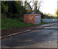
Viaduct Way electricity substation, Bassaleg
The identifier is N0012024.
Image: © Jaggery
Taken: 14 Nov 2013
0.02 miles
2
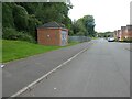
Electricity infrastructure building, Viaduct Way, Bassaleg
Image: © David Smith
Taken: 25 Sep 2021
0.02 miles
3
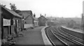
Bassaleg Station
View westward, towards Machen, Caerphilly, Merthyr etc.; former Brecon & Merthyr line, Newport - Brecon, closed 31/12/62, although this section remains open to Goods as far as Machen Quarry.
Image: © Ben Brooksbank
Taken: 31 May 1962
0.03 miles
4
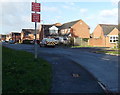
Advisory speed limit 5mph along Viaduct Way, Bassaleg
These don't appear to be official notices.
Image: © Jaggery
Taken: 14 Nov 2013
0.03 miles
5
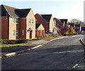
Viaduct Way houses, Bassaleg
Located between Viaduct Close behind the camera and Viaduct View ahead.
Image: © Jaggery
Taken: 14 Nov 2013
0.03 miles
6

Old railway notice on the side wall of Junction 28 restaurant, Bassaleg, Newport
The restaurant http://www.geograph.org.uk/photo/3744673 occupies what used to be the Machen-bound or up platform of Bassaleg's Brecon and Merthyr railway station. The lack of any punctuation is interesting. Perhaps this was how railway notices of the period (possibly late Victorian or Edwardian) were written in this area.
There is no indication whether or not this notice was originally on this site.
Image: © Jaggery
Taken: 14 Nov 2013
0.04 miles
7
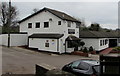
Junction 28 restaurant, Station Approach, Bassaleg
The restaurant is in a converted former building on what used to be the Machen-bound or up platform of Bassaleg's Brecon and Merthyr railway station. Passenger services at the station ended in 1962. The restaurant's name refers to the nearby M4 motorway junction.
Image: © Jaggery
Taken: 19 Mar 2019
0.04 miles
8
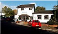
Entrance to Junction 28 restaurant in Bassaleg, Newport
Viewed across Station Approach. The restaurant is built on what used to be the Machen-bound or up platform of Bassaleg's Brecon and Merthyr railway station.
Image: © Jaggery
Taken: 14 Nov 2013
0.05 miles
9
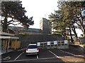
Priority parking for church hall users, Bassaleg
The small parking area is alongside St Basil's church hall. http://www.geograph.org.uk/photo/3744428
St Basil's Church is in the background.
Image: © Jaggery
Taken: 14 Nov 2013
0.05 miles
10
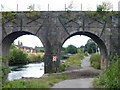
Railway Viaduct, Bassaleg
This viaduct crosses the River Ebbw and carries a freight line to Machen Quarry.
Image: © Robin Drayton
Taken: 13 Aug 2007
0.05 miles