IMAGES TAKEN NEAR TO
Melindwr, NEWPORT, NP10 8GL
Introduction
This page details the photographs taken nearby to Melindwr, NP10 8GL by members of the Geograph project.
The Geograph project started in 2005 with the aim of publishing, organising and preserving representative images for every square kilometre of Great Britain, Ireland and the Isle of Man.

There are currently over 7.5m images from over14,400 individuals and you can help contribute to the project by visiting https://www.geograph.org.uk
Image Map
Images are licensed for reuse under creativecommons.org/licenses/by-sa/2.0
Notes
- Clicking on the map will re-center to the selected point.
- The higher the marker number, the further away the image location is from the centre of the postcode.
Image Listing (44 Images Found)
Images are licensed for reuse under creativecommons.org/licenses/by-sa/2.0
Image
Details
Distance
1
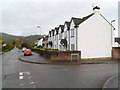
Six semis, Draethen
Six large semi-detached houses, a pair painted white either side of two central brown stone semis. They are numbers 1 to 6 Melindwr, Draethen. Higher numbered Melindwr houses are out of shot on the right.
Image: © Jaggery
Taken: 18 Nov 2011
0.03 miles
2
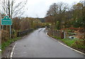
Eastern boundary of Draethen
The road http://www.geograph.org.uk/photo/2699726 SW from the A468 reaches Draethen, a small village about 3 miles SE of Caerphilly. Ahead is a bridge, Pont y Draethen, across the Rhymney River.
Image: © Jaggery
Taken: 18 Nov 2011
0.08 miles
3
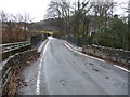
Pont y Draethen, Draethen
Looking east across Pont y Draethen, a bridge across the Rhymney River at the eastern edge of the village of Draethen. The sides of the bridge are partly old stonework and partly modern metal fencing.
Image: © Jaggery
Taken: 18 Nov 2011
0.08 miles
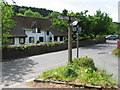
4
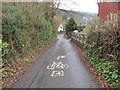
Celtic Trail at Draethen
The instruction painted on the road refers to the next junction - not the next driveway!
Image: © John Light
Taken: 9 Mar 2012
0.08 miles
5
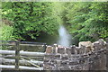
Rhymney River below Pont y Draethen
Looking downstream from the road bridge with a 'patched-up' parapet.
Image: © M J Roscoe
Taken: 21 May 2019
0.09 miles
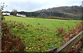
6
Afon Rhymni, Draethen
Llwybr Cylchdaith Afon Rhymni yn Nraethen. Mae Afon Rhymni wedi ei glanhau gymaint fel bod ganddi boblogaeth iachus o frillyth a phenllwydion.
The Rhymni River Circular Path, Draethen. The river, no longer polluted, supports a healthy population of brown trout and grayling.
Image: © Alan Richards
Taken: 3 Nov 2013
0.09 miles
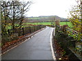
8
A distant view of wooded hillside near Draethen
A view from near Pont y Draethen http://www.geograph.org.uk/photo/2699755 across a field to houses on the road to Rhyd-y-Gwern and the wooded hillside beyond.
Image: © Jaggery
Taken: 18 Nov 2011
0.09 miles
9
Road bridge near Draethen
Pont y Draethen over the Afon Rhymni / River Rhymney.
Image: © Jeremy Bolwell
Taken: 4 Mar 2012
0.11 miles
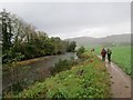
10
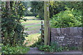
Start of footpaths from road, Pont-y-Draethen
The Rhymney River Circular Walk veers to the right on a permissive path; a public footpath veers to the left across the stubble field.
Image: © M J Roscoe
Taken: 17 Aug 2019
0.11 miles