IMAGES TAKEN NEAR TO
Rhyd-y-Gwern Lane, NEWPORT, NP10 8GH
Introduction
This page details the photographs taken nearby to Rhyd-y-Gwern Lane, NP10 8GH by members of the Geograph project.
The Geograph project started in 2005 with the aim of publishing, organising and preserving representative images for every square kilometre of Great Britain, Ireland and the Isle of Man.

There are currently over 7.5m images from over14,400 individuals and you can help contribute to the project by visiting https://www.geograph.org.uk
Image Map
Images are licensed for reuse under creativecommons.org/licenses/by-sa/2.0
Notes
- Clicking on the map will re-center to the selected point.
- The higher the marker number, the further away the image location is from the centre of the postcode.
Image Listing (45 Images Found)
Images are licensed for reuse under creativecommons.org/licenses/by-sa/2.0
Image
Details
Distance
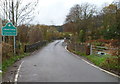
1
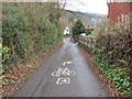
Celtic Trail at Draethen
The instruction painted on the road refers to the next junction - not the next driveway!
Image: © John Light
Taken: 9 Mar 2012
0.03 miles
2
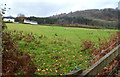
A distant view of wooded hillside near Draethen
A view from near Pont y Draethen http://www.geograph.org.uk/photo/2699755 across a field to houses on the road to Rhyd-y-Gwern and the wooded hillside beyond.
Image: © Jaggery
Taken: 18 Nov 2011
0.04 miles
3
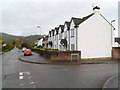
Six semis, Draethen
Six large semi-detached houses, a pair painted white either side of two central brown stone semis. They are numbers 1 to 6 Melindwr, Draethen. Higher numbered Melindwr houses are out of shot on the right.
Image: © Jaggery
Taken: 18 Nov 2011
0.04 miles
5
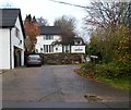
Ffynnon Cottage, Draethen
Set back 20 metres from the roadway. Ffynnon is Welsh for spring or fountain.
The Old Brew House http://www.geograph.org.uk/photo/2699863 is on the left.
Image: © Jaggery
Taken: 18 Nov 2011
0.05 miles
6
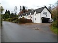
The Old Brew House, Draethen
At first glance, the six gabled dormer windows suggest that there are several properties here, perhaps a small row of cottages, but the former brew house is a single private residence.
Image: © Jaggery
Taken: 18 Nov 2011
0.05 miles
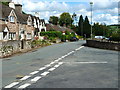
8
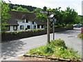
A view from crossroads, Draethen
Village houses viewed from the junction of three roads. The signpost points ahead for Rudry and Lisvane, behind the camera to Lower Machen and to the side for Rhyd-y-gwern.
Image: © Jaggery
Taken: 18 Nov 2011
0.08 miles
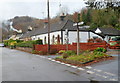
9

Village signpost with phone box, Draethen
Image: © Ruth Sharville
Taken: 7 Sep 2010
0.09 miles
10
Eastern boundary of Draethen
The road http://www.geograph.org.uk/photo/2699726 SW from the A468 reaches Draethen, a small village about 3 miles SE of Caerphilly. Ahead is a bridge, Pont y Draethen, across the Rhymney River.
Image: © Jaggery
Taken: 18 Nov 2011
0.09 miles