IMAGES TAKEN NEAR TO
Rhymney Way, NEWPORT, NP10 8FP
Introduction
This page details the photographs taken nearby to Rhymney Way, NP10 8FP by members of the Geograph project.
The Geograph project started in 2005 with the aim of publishing, organising and preserving representative images for every square kilometre of Great Britain, Ireland and the Isle of Man.

There are currently over 7.5m images from over14,400 individuals and you can help contribute to the project by visiting https://www.geograph.org.uk
Image Map
Images are licensed for reuse under creativecommons.org/licenses/by-sa/2.0
Notes
- Clicking on the map will re-center to the selected point.
- The higher the marker number, the further away the image location is from the centre of the postcode.
Image Listing (158 Images Found)
Images are licensed for reuse under creativecommons.org/licenses/by-sa/2.0
Image
Details
Distance
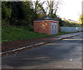
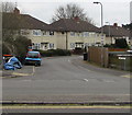
1
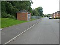
Electricity infrastructure building, Viaduct Way, Bassaleg
Image: © David Smith
Taken: 25 Sep 2021
0.06 miles
2
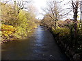
Ebbw flows away from a footbridge between Rogerstone and Bassaleg
Viewed from here. http://www.geograph.org.uk/photo/3749376 The river flows past houses in Viaduct Close, Bassaleg on the right.
Image: © Jaggery
Taken: 14 Nov 2013
0.06 miles
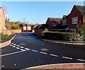
3
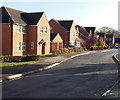
Viaduct Way houses, Bassaleg
Located between Viaduct Close behind the camera and Viaduct View ahead.
Image: © Jaggery
Taken: 14 Nov 2013
0.07 miles
4
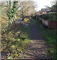
Riverside track, Bassaleg
The track heads east between the south bank of the River Ebbw and houses in Viaduct Close.
Image: © Jaggery
Taken: 14 Nov 2013
0.07 miles
5
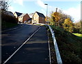
Newly-built houses viewed from Viaduct Way, Bassaleg
Viewed in November 2013. These houses are so new that they don't yet appear in the online maps I use. As I didn't go towards the houses, I don't know if this is a continuation of Viaduct Way, or if there is another name for the road ahead.
Image: © Jaggery
Taken: 14 Nov 2013
0.07 miles
6
Viaduct Close, Bassaleg
Viewed across Viaduct Way. Viaduct Close is on the south bank of the River Ebbw.
Image: © Jaggery
Taken: 14 Nov 2013
0.07 miles
7
Viaduct Way electricity substation, Bassaleg
The identifier is N0012024.
Image: © Jaggery
Taken: 14 Nov 2013
0.07 miles
8
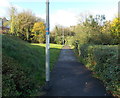
Bassaleg end of a path to Rogerstone
Viewed from the Viaduct Way end. The path (combined footpath and cycleway) crosses a river footbridge ahead.
Image: © Jaggery
Taken: 14 Nov 2013
0.07 miles
9
Junction of Ruperra Close and Church Crescent, Bassaleg
The western end of Ruperra Close viewed across Church Crescent.
Image: © Jaggery
Taken: 19 Mar 2019
0.08 miles
10
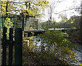
River footbridge between Rogerstone and Bassaleg
The bridge across the Ebbw is for walkers and cyclists. Bassaleg is on the south bank of the river.
On the north bank is Tregwilym Industrial Estate, leading to Rogerstone and High Cross.
Image: © Jaggery
Taken: 14 Nov 2013
0.08 miles