IMAGES TAKEN NEAR TO
Brigantine Close, NEWPORT, NP10 8ES
Introduction
This page details the photographs taken nearby to Brigantine Close, NP10 8ES by members of the Geograph project.
The Geograph project started in 2005 with the aim of publishing, organising and preserving representative images for every square kilometre of Great Britain, Ireland and the Isle of Man.

There are currently over 7.5m images from over14,400 individuals and you can help contribute to the project by visiting https://www.geograph.org.uk
Image Map
Images are licensed for reuse under creativecommons.org/licenses/by-sa/2.0
Notes
- Clicking on the map will re-center to the selected point.
- The higher the marker number, the further away the image location is from the centre of the postcode.
Image Listing (68 Images Found)
Images are licensed for reuse under creativecommons.org/licenses/by-sa/2.0
Image
Details
Distance
1
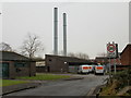
Duffryn Boiler House
The boiler house is part of Duffryn Communal District Heating System, managed by Newport City Homes.
Newport City Homes (NCH) came into existence in March 2009, after Newport City Council transferred its housing stock to the new organisation. NCH provides services to over 9,000 residents, leaseholders and shared owners in the city.
Image: © Jaggery
Taken: 21 Jan 2010
0.05 miles
2
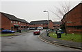
Henry Morgan Close, Duffryn
Viewed from Duffryn Way.
Image: © Jaggery
Taken: 21 Jan 2010
0.05 miles
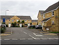
3
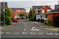
Brigantine Drive, Duffryn, Newport
Viewed across Morgan Way.
Image: © Jaggery
Taken: 10 Aug 2016
0.10 miles
4
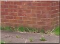
Ordnance Survey Cut Mark
This OS cut mark can be found on No1 Mallard Way. It marks a point 7.130m above mean sea level.
Image: © Adrian Dust
Taken: 2 Aug 2021
0.10 miles
5
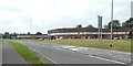
Duffryn Way and part of Tredegar Park housing estate
Image: © David Smith
Taken: 25 Sep 2021
0.10 miles
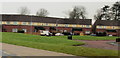
6
Part of Tredegar Park housing estate
The housing estate has modern terraced houses, laid out in a sinuous pattern
Image: © David Smith
Taken: 25 Sep 2021
0.11 miles
7
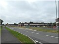
Mallard Way, Duffryn
Viewed from Duffryn Way. Mallard Way is part of a large housing estate built by the council in the 1970s. The estate is made up of long terraces looping around an area whose centre contains Duffryn Junior and Infants School and a wood.
Image: © Jaggery
Taken: 21 Jan 2010
0.11 miles
8
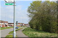
Sirhowy Valley Walk, Duffryn Way
The Sirhowy Valley Walk follows the pavement having joined the Way from Tredegar House Drive (sign on lamp post). Duffryn housing estate is on the left.
Image: © M J Roscoe
Taken: 10 Apr 2021
0.11 miles
9
Traffic calmed area, Schooner Circle, Duffryn, Newport
Viewed across Morgan Way. The blue sign on the left shows Traffic calmed area and the Welsh equivalent.
Image: © Jaggery
Taken: 10 Aug 2016
0.12 miles
10
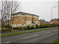
Providence House, Newport
6-apartment building at the west end of Schooner Circle, viewed across Morgan Way.
A similar apartment building, Chargres House, http://www.geograph.org.uk/photo/1923352 is a little further east along Morgan Way.
Image: © Jaggery
Taken: 21 Jan 2010
0.12 miles