IMAGES TAKEN NEAR TO
Cefn Llogell Lane, NP10 8DF
Introduction
This page details the photographs taken nearby to Cefn Llogell Lane, NP10 8DF by members of the Geograph project.
The Geograph project started in 2005 with the aim of publishing, organising and preserving representative images for every square kilometre of Great Britain, Ireland and the Isle of Man.

There are currently over 7.5m images from over14,400 individuals and you can help contribute to the project by visiting https://www.geograph.org.uk
Image Map
Images are licensed for reuse under creativecommons.org/licenses/by-sa/2.0
Notes
- Clicking on the map will re-center to the selected point.
- The higher the marker number, the further away the image location is from the centre of the postcode.
Image Listing (4 Images Found)
Images are licensed for reuse under creativecommons.org/licenses/by-sa/2.0
Image
Details
Distance
1
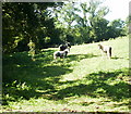
Horsy trio in field near M4, Coedkernew
Horses turn to see who has intruded on their domain in a field close to the underpass from Blacksmiths Way, on the Cefn Llogell side of the M4 motorway.
Image: © Jaggery
Taken: 9 Sep 2009
0.17 miles
2
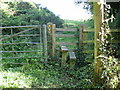
Stile on Castleton Circular Walk
Close to the north side of the M4 motorway, near the underpass from Blacksmiths Way
Image: © Jaggery
Taken: 9 Sep 2009
0.17 miles
3
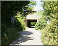
Under the M4, Coedkernew
The lane from Blacksmiths Way goes under the motorway here and continues towards
Cefn Llogell
Image: © Jaggery
Taken: 9 Sep 2009
0.21 miles
4
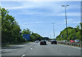
On the M4 heading west approaching the A48(M) junction
Image: © Rob Purvis
Taken: 21 May 2023
0.21 miles