IMAGES TAKEN NEAR TO
Ladys Well Place, NEWPORT, NP10 8BT
Introduction
This page details the photographs taken nearby to Ladys Well Place, NP10 8BT by members of the Geograph project.
The Geograph project started in 2005 with the aim of publishing, organising and preserving representative images for every square kilometre of Great Britain, Ireland and the Isle of Man.

There are currently over 7.5m images from over14,400 individuals and you can help contribute to the project by visiting https://www.geograph.org.uk
Image Map
Images are licensed for reuse under creativecommons.org/licenses/by-sa/2.0
Notes
- Clicking on the map will re-center to the selected point.
- The higher the marker number, the further away the image location is from the centre of the postcode.
Image Listing (34 Images Found)
Images are licensed for reuse under creativecommons.org/licenses/by-sa/2.0
Image
Details
Distance
1
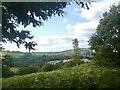
View towards the north-west, Gaer Fort, Newport.
Looking over houses at Pye Corner.
Image: © Robin Drayton
Taken: 28 Aug 2021
0.08 miles
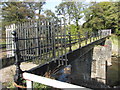
2
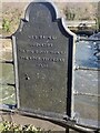
Inscription on old footbridge, Tredegar Park
The inscription reads :
MR R RAINE
SURVEYOR
TO THE RIGHT HONBLE
THE LORD TREDEGAR
1870
This was Charles Morgan Robinson Morgan who became Baron Tredegar in 1859 and died 1875.
It appears that a crest has been removed from the top of the metal plate.
Image: © Robin Drayton
Taken: 22 Feb 2021
0.10 miles
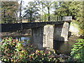
3
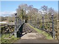
Old footbridge over the River Ebbw
The Coflein (Royal Commission on the Ancient and Historical Monuments of Wales) website states
“Tredegar Park Tramroad connects Tredegar Park Forge with Sir Charles Morgan's Park Mile Railway.
The tramroad crosses River Ebbw on stone-piered bridge, with a later (1870) cast iron span.”
It is situated in what was Lord Tredegar’s Deer Park.
In the 20th century it gave access from the Tredegar Park Golf Course clubhouse to the fairways.
Image: © Robin Drayton
Taken: 22 Feb 2021
0.10 miles
4
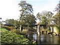
Bridge across the River Ebbw
An old footbridge across the River Ebbw. The bridge, shown as a footbridge on current OS maps, is presently closed, and lies in the grounds of the former Tredegar House deer park.
Image: © Gareth James
Taken: 31 Oct 2016
0.10 miles
5
Bridge across the River Ebbw
An old footbridge across the River Ebbw. The bridge, shown as a footbridge on current OS maps, is presently closed. One of the pillars appears to have a distinct list, which may (or may not) be the cause of the closure. The bridge lies within the grounds of the former Tredegar House deer park.
Image: © Gareth James
Taken: 31 Oct 2016
0.10 miles
6
Bridge across the River Ebbw
An old footbridge across the River Ebbw. The bridge, shown as a footbridge on current OS maps, is presently closed, and lies in the grounds of the former Tredegar House deer park. At least one source states this bridge to have once carried a tramroad.
Image: © Gareth James
Taken: 31 Oct 2016
0.10 miles
7
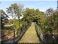
Bridge across the River Ebbw
An old footbridge across the River Ebbw. The bridge, shown as a footbridge on current OS maps, is presently closed, and lies in the grounds of the former Tredegar House deer park. At least one source states this bridge to have once carried a tramroad.
Image: © Gareth James
Taken: 31 Oct 2016
0.10 miles
8
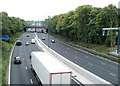
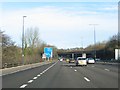
Motorway railway bridge viewed from Bassaleg Road, Newport
A view south along the M4 motorway towards the bridge carrying a two-track railway line, on the Cardiff to Ebbw Vale passenger route. Viewed from Bassaleg Road bridge. http://www.geograph.org.uk/photo/2079396
Image: © Jaggery
Taken: 21 Jul 2011
0.13 miles
9
Railway bridge over the M4
This bridge (between junctions 27 and 28) carries the railway to Ebbw Vale over the M4. Currently only used for freight, there are plans to reinstate passenger services. [Looking N]
Image: © John Thorn
Taken: 21 Jan 2006
0.13 miles
10
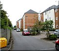
Golden Mile View flats, Newport
The flats, on the SW side of Bassaleg Road, are contained in several individually-named buildings. Beyond the hedge and fence on the left are railway lines formerly part of the Golden Mile. http://www.geograph.org.uk/photo/2528638
Image: © Jaggery
Taken: 21 Jul 2011
0.13 miles