IMAGES TAKEN NEAR TO
Charger Street, NEWPORT, NP10 8BH
Introduction
This page details the photographs taken nearby to Charger Street, NP10 8BH by members of the Geograph project.
The Geograph project started in 2005 with the aim of publishing, organising and preserving representative images for every square kilometre of Great Britain, Ireland and the Isle of Man.

There are currently over 7.5m images from over14,400 individuals and you can help contribute to the project by visiting https://www.geograph.org.uk
Image Map
Images are licensed for reuse under creativecommons.org/licenses/by-sa/2.0
Notes
- Clicking on the map will re-center to the selected point.
- The higher the marker number, the further away the image location is from the centre of the postcode.
Image Listing (39 Images Found)
Images are licensed for reuse under creativecommons.org/licenses/by-sa/2.0
Image
Details
Distance
1
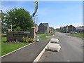
The Boulevards
This picture from 2010 shows this location as the entrance to a factory. Image
That has obviously gone and it's now new housing.
Image: © Des Blenkinsopp
Taken: 8 May 2016
0.04 miles
2
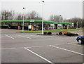
Asda filling station, Duffryn
Located at the southwest edge of Asda's superstore site. http://www.geograph.org.uk/photo/1673287
Image: © Jaggery
Taken: 21 Jan 2010
0.15 miles
3

Imperial Park, Newport
Surface Technology Systems
Image: © Kev Griffin
Taken: 16 Nov 2004
0.15 miles
4
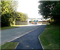
Eastern end of Grosmont Way, Newport
Viewed from near the roundabout at the Morgraig Avenue and White Avenue junctions.
Image: © Jaggery
Taken: 21 Dec 2012
0.15 miles
5
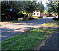
Cycle route signs, Morgraig Avenue, Newport
A small label on the sign pole on the left shows that this route is part of National Cycle Network Route 88, a mainly coastal route from Newport to Margam Country Park via Cardiff and Bridgend. In August 2018, only short sections of the route are open.
Image: © Jaggery
Taken: 13 Aug 2018
0.15 miles
6
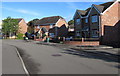
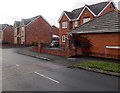
Grosmont Way houses, Newport
Detached houses viewed from the corner of Morgraig Avenue.
Image: © Jaggery
Taken: 13 Aug 2018
0.15 miles
7
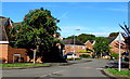
West along Grosmont Way, Newport
The eastern end of Grosmont Way viewed from the roundabout
at the Morgraig Avenue/White Avenue/Grosmont Way crossroads.
Image: © Jaggery
Taken: 13 Aug 2018
0.15 miles
8
Entrance to Panasonic factory, Newport
The entrance drive and pavement is from Pencarn Way roundabout.
Image: © Jaggery
Taken: 25 Sep 2010
0.16 miles
9
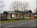
St Joseph's RC High School, Duffryn
Located adjacent to the Asda superstore. http://www.geograph.org.uk/photo/1673287
Image: © Jaggery
Taken: 21 Jan 2010
0.16 miles
10
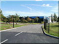
Entrance to STS, Imperial Park, Newport
The entrance from South Lake Drive into the Corporate Headquarters of STS (Surface Technology Systems plc), providers of specialist plasma etch and deposition systems, used in the manufacture of various semiconductor products.
Image: © Jaggery
Taken: 25 Sep 2010
0.16 miles